April 24, 2024
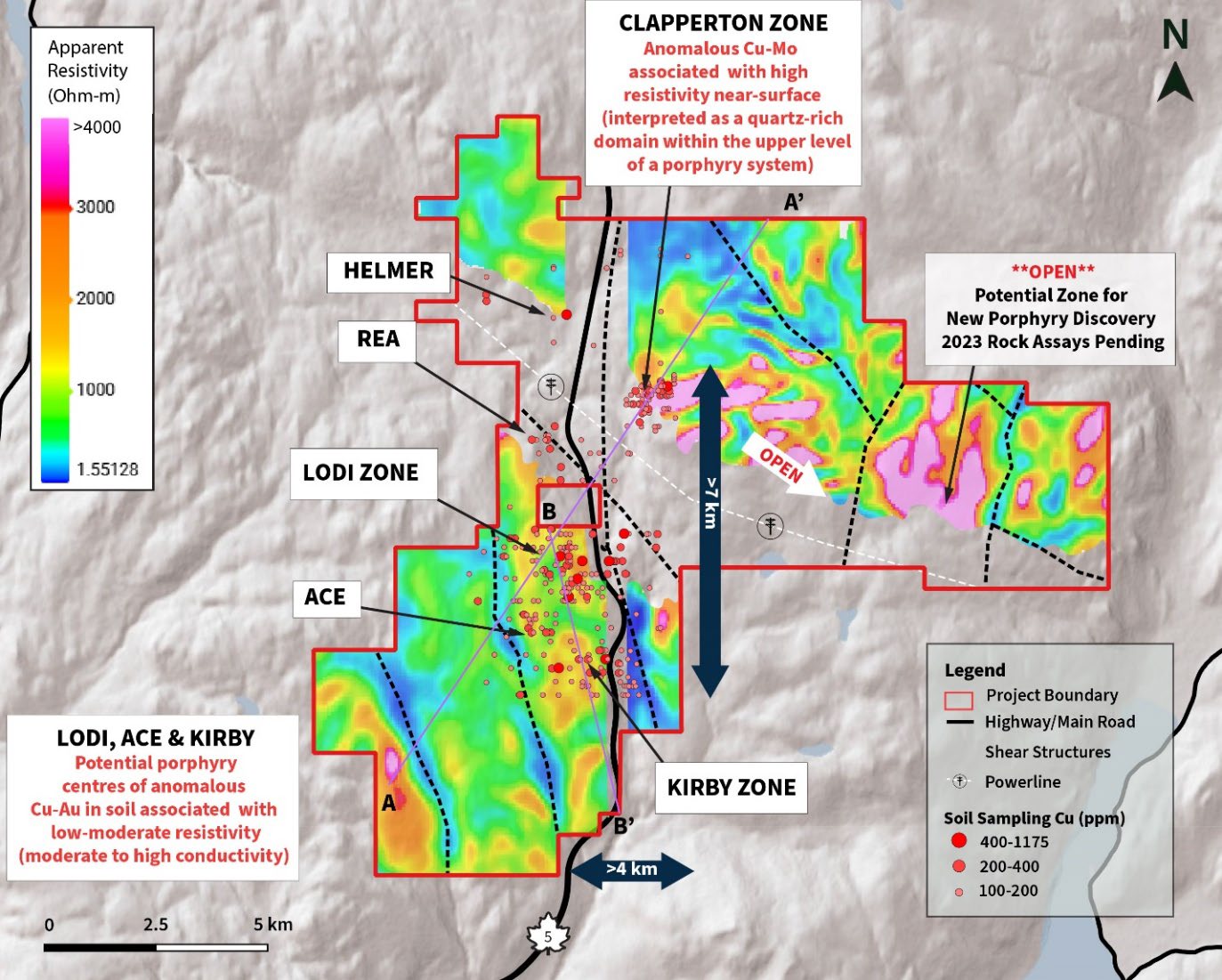
Vancouver, British Columbia (BC) — (April 24, 2024) – Torr Metals Inc. (“Torr” or the “Company“) (TSX-V: TMET.V) is very pleased to announce preliminary results that have identified near-surface high priority geophysical resistivity anomalies extending up to >1.5 kilometers (km) depth that are coincident with highly anomalous copper (Cu), gold (Au), and molybdenum (Mo) mineralization at-surface (Figure 1). These compelling exploration drill targets have been identified using a newly completed 3D resistivity inversion voxel model, derived from the ZTEM geophysical survey completed over the entirety of the 100% owned ~140 km2 Kolos Copper-Gold Project in late 2023 (Figure 1).
The geophysical survey data was analyzed in conjunction with recently published soil geochemistry, revealing a multi-centred cluster porphyry trend spanning 7 kilometers (km) (see March 25, 2024 news release). This trend encompasses 5 priority exploration targets for Cu-Au and Cu-Mo that delineate potential porphyry centres, all of which have never been drilled. Each target zone is defined by >200 parts per million (ppm) Cu in soil with concentrations reaching a peaks of 1175 ppm Cu and 725 ppb Au (Figure 1). All of the priority exploration targets are road-accessible from Highway 5, approximately 23 km north-northeast of the city of Merritt, British Columbia.
Highlights:
- Kilometre-scale Surface Exploration Targets Now Extended to Depth: The results of the 3D resistivity inversions have confirmed multiple untested sub-surface drilling opportunities with 3 major potential porphyry centres within the Lodi, Kirby, and Clapperton Zones together with 2 additional satellite Cu-Au porphyry epithermal targets within the Ace and Rea Zones.
- Multiple Broad Resistivity Anomalies Indicate Impressive Scale: Across the Lodi, Kirby, and Clapperton Zones, extensive low to moderate and high resistivity anomalies span multiple kilometers in the sub-surface, aligning with concentrated higher-grade Cu ± Au ± Mo mineralization at the surface (Figure 1).
-
- Multiple Large-Scale Geophysical Anomalies Coincident with Surface Mineralization:
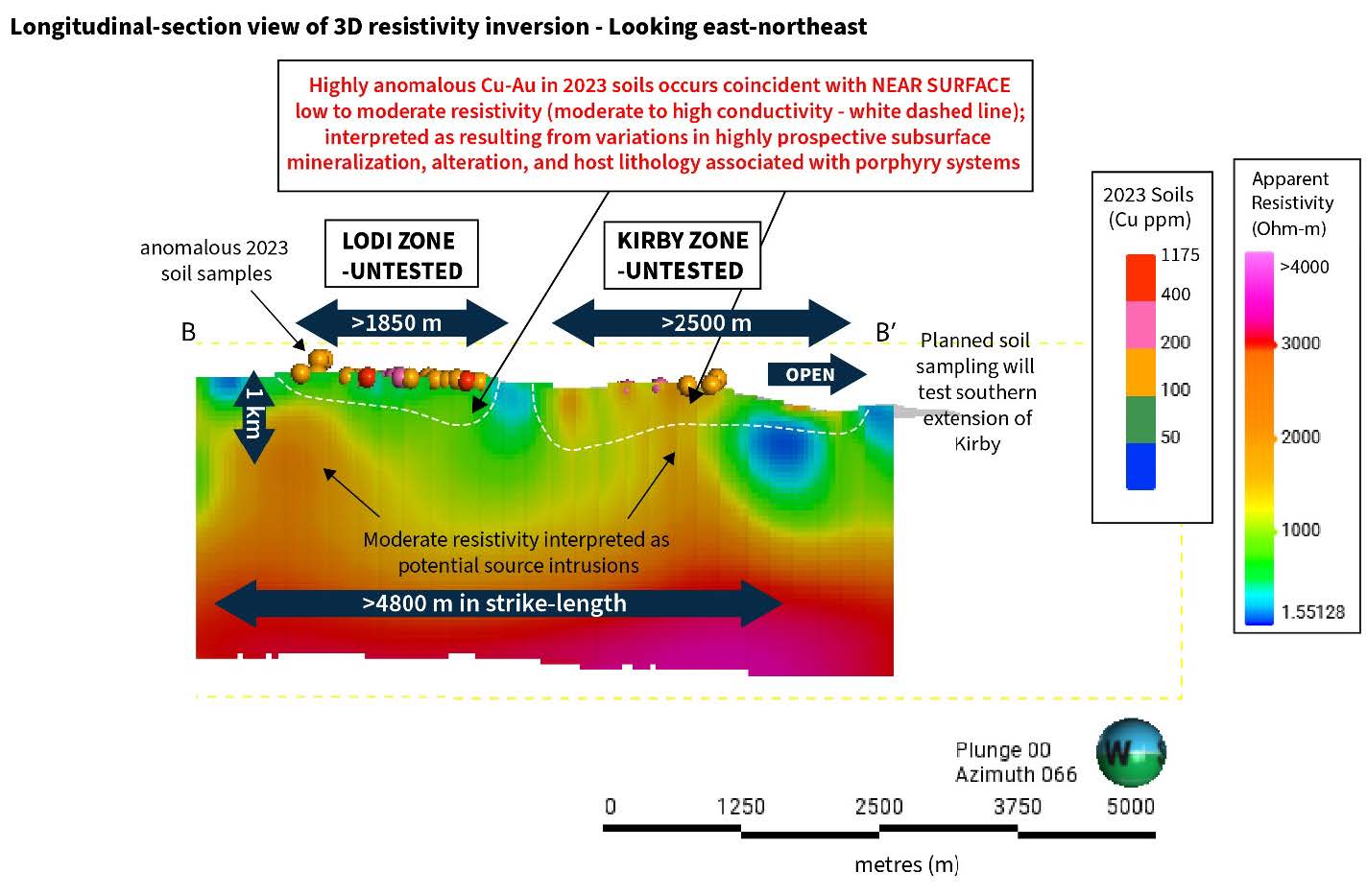
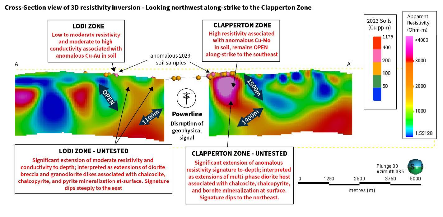
- Analysis has confirmed an extensive anomalous resistivity signature, stretching over 4.8 km in strike-length, connecting the Cu-Au Lodi and Kirby Zones at depth (Figure 2). Copper-gold mineralization in both zones has a strong correlation to anomalous low to moderate resistivity, with anomalous signatures extending up to 1000 meters (m) in depth while measuring ~1850 m and ~2500 m in strike-length within the Lodi and Kirby Zones respectively (Figure 2, Figure 3).
- Anomalous copper-molybdenum in soil coincides with an at-surface high resistivity anomaly at the Clapperton Zone, attributed to an exposed quartz-rich domain, typical of the upper levels of a porphyry system, within a multi-phase diorite intrusive host; resulting in an anomalous geophysical signature measuring ~1400 m in width and >1500 m in depth (Figure 3).
- Multiple Large-Scale Geophysical Anomalies Coincident with Surface Mineralization:
- Kirby Zone Expansion Potential: The anomalous geophysical signature at the Kirby Zone extends >1900 m south of the 2023 soil grid, suggesting significant expansion potential with further soil sampling.
“The strong correlation between highly anomalous resistivity areas and known surface copper-gold and copper-molybdenum mineralization is incredibly promising,” said Malcolm Dorsey, President and CEO. “We are now identifying the robust plumbing behind these prolific mineralizing systems, indicating an immense scale of underlying potential. Torr is now equipped with the precise knowledge on where and how to best target these anomalies in the sub-surface and with multiple untested zones delineated across a 7 km cluster porphyry trend this is a significant opportunity for a potentially major new copper discovery located only 30 km from Canada’s largest open pit copper mine at Highland Valley.”
ZTEM Geophysical Survey
ZTEM geophysics is a sophisticated technique for delineating expansive hydrothermal mineralization and alteration systems typically associated with porphyry deposits, often spanning kilometer-scale dimensions both horizontally and vertically. Moreover, its precision in defining intricate geological structures proves invaluable, aiding in the identification and localization of mineralization; thereby enhancing exploration efficiency and success.
Figure 1. Kolos Project area with highly anomalous 2023 soil samples and ZTEM resistivity inversion at 200m vertical depth. Note that gaps in the data were caused by powerline disruption and location of Highway 5.
Figure 2. ZTEM 3D Resistivity Inversion Model voxel slice through the Lodi and Kirby Zones, view looking east-northeast.
Figure 3. ZTEM 3D Resistivity Inversion Model voxel slice through the Lodi and Clapperton Zones, view looking northwest.
Quality Assurance and Control
Results from samples were analyzed at ALS Global Laboratories (Geochemistry Division) in Vancouver, Canada (an ISO/IEC 17025:2017 and ISO 9001:2015 accredited facility). A secure chain of custody is maintained in transporting and storing of all samples. At ALS the “B” horizon soil samples underwent screening to 180 microns under the ALS code PREP-41. The samples were digested using Aqua Regia and analyzed via ICP-MS and ICP-AES using a 25g sample aliquot under the ALS code AuME-TL43. The Company follows industry standard procedures for the work carried out on the Kolos Project. Due to the reconnaissance nature of the soil sampling the Company relied on the internal quality assurance quality control (“QA/QC”) measures of ALS. Torr Metals detected no significant QA/QC issues during review of the data.
Qualified Person
The technical content of this news release has been reviewed and approved by Michael Dufresne, M.Sc., P.Geol., P.Geo., a consultant to the Company who is a qualified person defined under National Instrument 43-101.
About Torr Metals
Torr Metals is a Vancouver based mineral exploration company focused on defining and developing the substantial exploration potential of the ~140 km2 Kolos Copper-Gold Project, located within the prolific Quesnel Terrane in Central British Columbia. Year-round access is provided by Highway 5, with the project being favourably located 23 km north of the city of Merritt and 286 km by highway from Vancouver, British Columbia. For further details about the Latham Copper-Gold Project, please refer to the Company’s website or current geological Technical Report (August 24, 2021) filed on November 25, 2021 under the Company’s profile on SEDAR at www.sedar.com.
On behalf of the Board of Directors
Torr Metals Inc.
“Malcolm Dorsey”
Malcolm Dorsey
President, CEO and Director
For further information:
Malcolm Dorsey
Telephone: 236-982-4300
Email: malcolmd@torrmetals.com
For the full article click here.


