Vancouver, British Columbia – September 9, 2020 – Starr Peak Exploration Ltd. (“Starr Peak” or the “Company”) (TSX VENTURE:STE) (OTC:STRPF) is very pleased to announce it has launched a VTEM survey covering the Main bloc of its NewMétal property (“NewMétal” or “the Property”) covering the past-producing Normétal Mine, from which ~10.1M tonnes of 2.15% Cu, 5.12% Zn, 0.549 g/t Au, and 45.25 g/t Ag were produced (Boivin, 1988) and the Normetmar showing. Additionally, a high resolution drone mag survey covering the entire property, including Rousseau and Turgeon Lake Gold, will be conducted to define gold structures and help identify drilling targets.
At the request of IIROC the Company wishes to clarify certain disclosures related to the press release of August 10, 2020; STARR PEAK EXPANDS NEWMÉTAL PROPERTY BY ACQUIRING 100% INTEREST OF PAST-PRODUCING NORMÉTAL MINE CLAIMS BLOC IN QUEBEC.
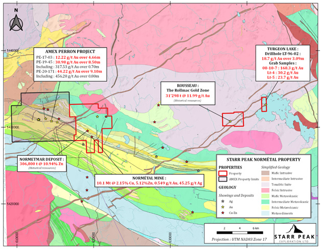
- The Normetmar showing has historical estimate of 306,800 tons of material grading 10.94% Zinc and was reported by Kerr Addison in the report GM38950 (1970).
- The Rousseau gold property includes the Rollmac gold zone which has an historical estimate of 31,298 tonnes grading 11.99 g/t Au (Historical resources; Northern Miner, July 13, 1992)
The Company wishes to caution that historical resources described above are historical. The historic resources are relevant to give a ballpark estimate of the potential on the property. Historical resources should not be relied upon. The key assumptions, parameters and methods used to prepare the historical estimate is not known and thus the difference between the historic estimates and NI 43-101 compliant estimates is also not known. The historical estimates used categories other than the ones set up in sections 1.2 and 1.3 of National Instrument 43-101, Standards of Disclosure for Mineral Projects. A qualified person has not reviewed the historical estimates and has not done sufficient work to classify the historical estimates as current mineral resources and Starr Peak is not treating the historical estimates as current mineral resources under National Instrument 43-101 and CIM Standards for mineral resources and reserves. Further exploration work needs to be done to correctly evaluate these historical resources. Additionally, the methodology of calculation is unknown by the qualified person.
Grab samples are selective by nature and the values reported may not be representative of the mineralized zone.
In the past week, numerous samples were also taken from the Rousseau gold property and the Turgeon Lake gold property. Grab samples of quartz vein collected from the Mercier vein and the Turgeon Lake showing will enable the Company to evaluate historical gold mineralization and determine the exploration potential of both showings.
Working with Laurentia Exploration, Starr Peak has also launched an initial program of compilation, prospecting, and geological mapping, and plans to complete an airborne EM survey and high-resolution MAG drone geophysics survey in the fall of 2020 in order to prepare for an inaugural drilling campaign in winter 2021.
Johnathan More, Chairman and CEO of Starr Peak commented,
“Both VTEM and high resolution drone magnetic geophysical surveys are sophisticated modern tools that will provide us with significant structural and geophysical signatures that we can use to fine tune and narrow future exploration on our vast property in the highly prospective Chicobi belt. By surveying the past producing mines and know historical resources on our properties we will be able to identify the structures and signatures that host gold mineralization as well as possible VMS systems and apply that knowledge elsewhere on the property. Our team has a history of identifying mineralization in this belt using modern exploration tools and I am excited to see the results and their interpretation.”
Figure 1: Geological Map of the NewMétal property with respect to Amex Exploration’s Perron Project.

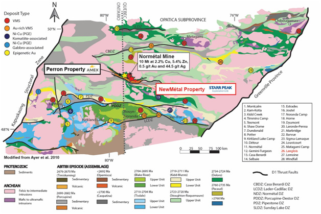
Figure 2: Regional Geology of the Abitibi Greenstone Belt and localisation of Starr Peak’s NewMétal Property.

The NewMétal Property is located in the Abitibi Greenstone Belt of Quebec, along the Chicobi Deformation Zone. The Property is directly adjacent to Amex Exploration Inc.’s Perron property, from which recently announced drill results include 44.22 g/t Au over 9.10 metres and 30.98 g/t Au over 8.50 metres.
The NewMétal Property is cross-cut by the Normetal Fault Horizon associated with gold and base metal mineralization along strike. The property is also located in the eastern extension of the Perron fault known to be a prolific gold bearing structure. Geology underlaying the Property consists of favourable rhyolite and mafic volcanic rocks, as well as diabase dikes and granitic intrusions. Two known mineral showings occur on the Property. The Rang I-Lots 44-57 showing was identified in diamond drilling in 1966, with samples reaching up to 0.02% Cu and 2.38% Zn over 0.15 metres in historical drillhole Sondage 1-66, and up to 1.02 g/t Au occurring over unknown widths in drillhole Sondage 93-05. The Perron-Desmeloizes-Nord showing is a surface showing identified in 1952 with select samples reaching up to 14.5 g/t Au.
Qualified Person
Alexis Paulin Bissonnette, Ing. (OIQ 5037621), an independent Qualified Person as defined by Canadian NI 43-101 standards, has reviewed and approved the geological information reported in this news release. The Qualified Person has not completed sufficient work to verify the historic information on the Property, particularly in regards to historical drill results. However, the Qualified Person believes that drilling and analytical results were completed to industry standard practices. The information provides an indication of the exploration potential of the Property but may not be representative of expected results.
References and disclosures
Perron-Desmeloizes-Nord: http://sigeom.mines.gouv.qc.ca/signet/classes/I1103_index?format=COMPLET&type_reqt=U&mode=NOUVELLE&l=A&entt=GM&numr_utls=2755180&alias_table_crit=F4E02&mnen_crit=NUMR_INTER&oper_crit=EGAL&valr_crit=4018
The Perron-Desmeloizes-Nord showing outcrop have been located on surface but the original 14,5 g/t Au grab sample have not been validated or located.
Starr Peak is not able to validate the Rang I-Lots 44-57 showing due to the age of the drill hole.
Amex Exploration Perron Project:
Amex Exploration Inc. Press Releases dated July 16, 2020 and May 21, 2019
Mineralization hosted on adjacent and/or nearby properties is not necessarily indicative of mineralization hosted on the Company’s property.
Normetal Mine:
Summary Report, Normetmar Project, January 1988 by L. Boivin
On Behalf of the Board of Directors of Starr Peak Exploration Ltd.,
“Johnathan More”
Johnathan More
Chairman and Chief Executive Officer
About Starr Peak Exploration Ltd.
Starr Peak Exploration Ltd. is a Canadian based mineral exploration company focused on the acquisition and exploration of precious and base metal mineral deposits. The primary objective of the Company is to acquire, explore and develop high potential and quality gold deposits and projects in the Americas. The Company is committed to create long term shareholder value through mineral discoveries.
For more information please contact:
Johnathan More, Chairman & CEO
Tel: 646-661-0409
https://www.starrpeakexploration.com/
For the full article click here.