Presented at ASEG-PESA 2015, Perth, Australia
For a PDF of this paper click here
Summary
As part of a regional scale 24,675 line-km survey covering a 25,000 km2 area (1 km line spacing) in the Selwyn Basin, ZTEM™ and magnetics were acquired over the ~250 Million tonne SEDEX resource at Howard’s Pass with ~4.5% Zn and ~1.5% Pb. The >37km long “zinc corridor” hosts as many as 15 known SEDEX deposits defined in the last 30 years since the initial discovery in 1972. The surveys highlighted a NW-SE conductive and weakly magnetic correlation with the >37km long “zinc-corridor” deposit area defined by drilling. 2D-3D inversions of the ZTEM™ and magnetic reveal a correlation between enhanced conductivity along strike and the clustering of deposits at Howard’s Pass. However, because the mineralized Active Member is thin (<30m), the conductor must also encompass the surrounding Howard’s Pass Fm. black shales units to be resolvable in the AEM results. This is explained either by enhanced mineralization in areas of thicker black shale sub-basins or simply separation of the mineralized and shale horizons by fault-displacement.
Introduction
The Selwyn Basin, which extends from Alaska to northern British Columbia, is considered one of the most productive Zn-Pb-Ag sedimentary exhalative (SEDEX) regions in the world, with more than a dozen major dozen deposits identified. The SEDEX deposits at Macmillan Pass and Howard’s Pass in east-central Yukon (Fig. 1) are believed to have the highest potential for development (Goodfellow, 2007). Howard’s Pass, in particular, is world class, with an estimated mineral potential of ~250M tonnes at 4-5% zinc and 1-2 % lead contained in 15 separate deposits that extend over a 37.5 km strike length (Kirkham et al., 2012). The Howard’s Pass deposit is owned by Chihong Canada Mining Ltd. (Vancouver, CAN) and is currently in pre-development. The results from a large regional EM survey over flown in 2008 (Witherly, 2013) with the ZTEM™ (z-axis tipper electromagnetic) helicopter EM and magnetic system (Lo and Zang, 2008) were described by Carne et al. (2014) and Legault et al. (2014). Our study focuses on the ZTEM™ and magnetic results of over the SEDEX deposits at Howard’s Pass.
Although EM is credited with the discovery of the Clear Lake SEDEX in central Selwyn Basin, stream and seep geochemistry, lithogeochemistry, mapping and prospecting, along with drilling are primarily used in the region (Goodfellow, 2007). Airborne geophysics has not been extensively used in SEDEX exploration of the Selwyn Basin, due to the lack of magnetic contrasts and similar conductivities of ores to the host black shales (Goodfellow, 2007; Witherly, 2014). Ground geophysics including magnetic, EM, SP, gravity, VLF and resistivity have been used at Howards Pass, but have proven ineffective at defining/discriminating the mineralized SEDEX horizons. However gravity and resistivity in particular were able to define stratigraphy under areas of cover (Burgoyne, 2005). Indeed the 2008 ZTEM™ survey of eastern Selwyn Basin was commissioned by Exploration Syndicate Inc. (ESI) to map regional lithologies and structures related to SEDEX deposits below thick overburden and sedimentary cover, based on resistivity contrasts (M. Zang, ESI, pers. comm., 2008).
While the SEDEX deposits in Selwyn Basin were initially discovered in the early 1950’s to late 1970’s (Goodfellow, 2007) and extensively explored since then (Witherly, 2014) airborne geophysical coverage in the Selwyn Basin is limited, with only a regional magnetic survey by the Geological Survey of Canada publically available. The 2008 Selwyn Basin ZTEM™ survey, recently purchased by the Yukon Geological Survey (Witherly, 2013), is one of the few available airborne AFMAG EM-magnetic data sets that also covers a variety of SEDEX and other types of mineral deposits (Carne et al., 2013).
Geology and Mineralization
The Howard’s Pass SEDEX deposits were discovered in 1972 using regional stream sampling for lead-zinc. Extensive soil sampling, trenching, mapping and drilling continue to guide exploration. The local geology in Howards Pass (Fig. 1) consists of Hadrynian to Cambrian basement phyllites and coarse clastics units that outcrop to the southeast of the property. These are followed by a thick sequence of Cambrian-Ordivician age Rabbitkettle limestones and calcareous mudstones. These are overlain by the Ordivician to Silurian Road River Group black shales that consist of Howard’s Pass Fm carbonaceous mudstones at the base, and flaggy and siliceous mudstones at the top. The Howard’s Pass Fm. includes the sulphide-rich Active Member unit that contains all the known zinc and lead mineralization at Howard’s Pass (see Fig. 2). The Road River Group is overlain by Devonian to Mississippian Lower and Upper Earn Group mudstones. The rocks have been intruded locally by Cretaceous felsic intrusions. The geology can be structurally complex, with the deposits to the southeast lying on the south limb of a large ~N-300O trending regional syncline, whereas to the northwest they lie on a steeply dipping, NW-trending contact (Burgoyne, 2005; O’Donnell, 2009; Kirkham et al., 2012).
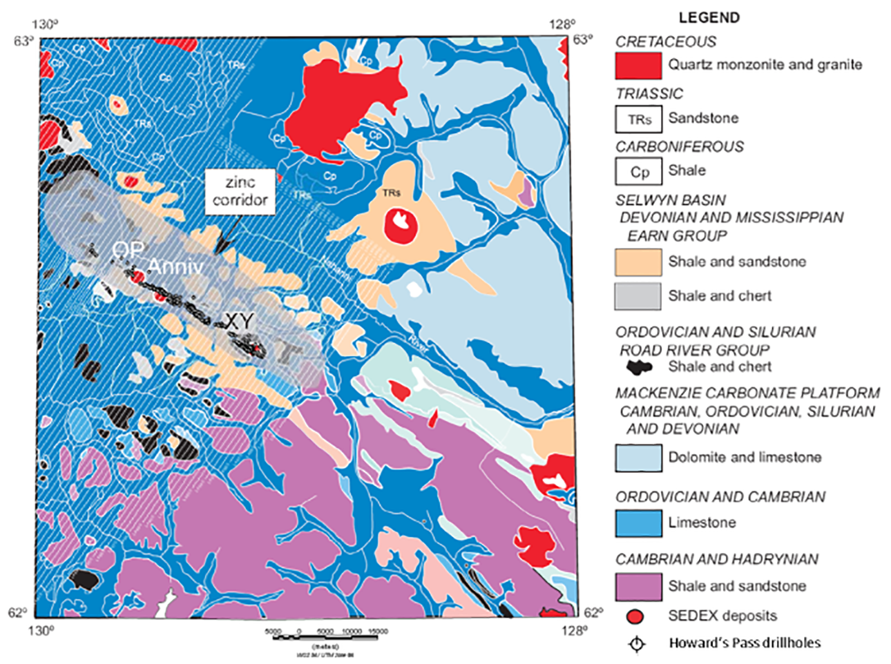
Figure 1: Howard’s Pass geology (after Goodfellow, 2007) with AEM flight lines (white) and drillholes at Howard’s Pass.
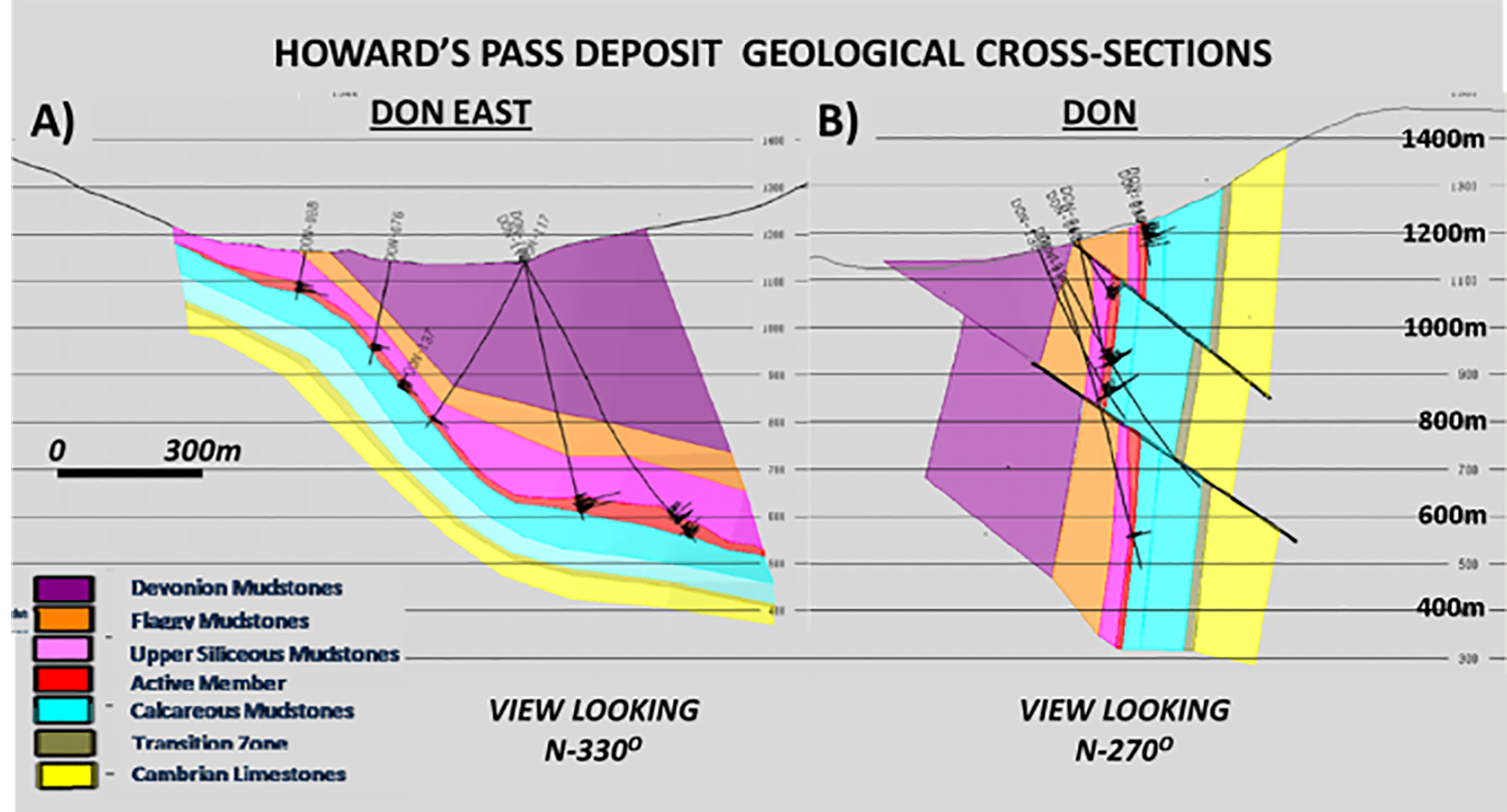
Figure 2: Howard’s Pass geological cross-sections at Don East (A) and Don deposits (B), showing complex structure, drillholes, and geologic units across HP valley (modified after O’Donnell, 2009).
The mineralized horizon at Howard’s Pass, referred to as the “zinc corridor” (see Fig. 1) trends NW-SE and extends for 37.5km, with the 15 drilled deposits and zones that are offset/separated by interpreted faults. The Active Member is generally 20-30m thick and consists of laminated, fine-grained sphalerite and galena with minor pyrite. Higher grade zones, like XY Central (45.11 Mt indicated @ 5.17% Zn & 2.49% Pb) and Don (36.90 Mt indicated @ 5.63% Zn & 2.11% Pb), are coarser grained, exhibit sulphide-remobilization, contain multiple lenses and occur near the base of the Active Member (Goodfellow, 2007; Kirkham et al., 2012).
Passive AEM & Magnetic Results
The ZTEM™ total divergence and magnetic TMI images over a 70x80km area that focuses on the Howard’s Pass SEDEX region are presented in Figures 3-4. They highlight a thin, NW-SE trending conductive and weak partially magnetic lineament that extends through the >37km long “zinc-corridor” deposit area as defined by drilling. Each of the 15 known SEDEX deposits, defined by ddh clusters and labelled by name (ref. Kirkham et al., 2012), overlie the Howard’s Pass (HP) ZTEM™ conductor. Because the mineralized Active Member is thin (<30m), the HP conductor must also encompass the surrounding Howard’s Pass Fm. black shales units to be resolvable in the AEM results. As shown, the HP ZTEM™ conductor flanks the southwest edge of a broader, 1-2km wide, high resistivity unit (carbonates), that is in turn flanked by another thin conductive lineament (barren shale units) on its north-eastern edge. The conductive band that hosts HP is the most prominent in the area and extends for ~70km – pinching to the northwest, just outside the focus area, and terminating to the SE where basement rocks outcrop (see Fig. 1).
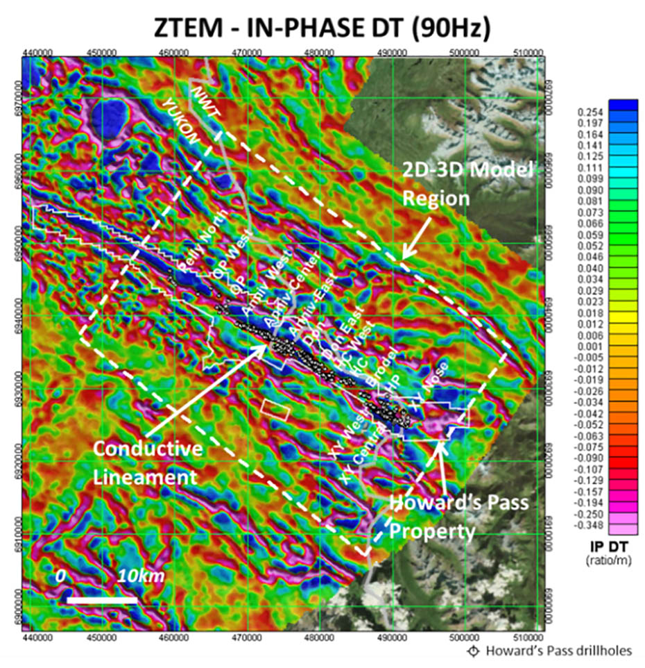
Figure 3: ZTEM 90Hz In-phase DT, over focus area at Howard’s Pass, highlighting conductive lineament and HP drillholes, known deposits and 2D-3D model region discussed below.
Figure 5 presents a resistivity-depth slice at 300m obtained from 2D ZTEM™ inversions (ref. Legault et al., 2012) across a 35x50km model region that is centred on the Howards Pass SEDEX deposits. It shows a narrower, slightly less uniform and more variably conductive trend along Howard’s Pass de-posit area than previously seen in the raw ZTEM™ data images. Interestingly, most of the deposits appear to be grouped/ clustered within areas of higher conductivity along strike (see Fig. 5), in particular the larger tonnage deposits at Anniv, Don-Don East and XY. Similar on-strike conductivity variations are observed in in the 3D inversion (not shown) obtained using UBC MT3dinv code (ref. Holtham and Oldenburg, 2008). This suggests possible enhanced mineralization in areas of thicker black shale sub-basins that are being defined with AEM. Alternately, this might simply reflect separation of the mineralized and shale horizons by fault-displacement. Both inversions show better strike continuity at greater depths (>500m).
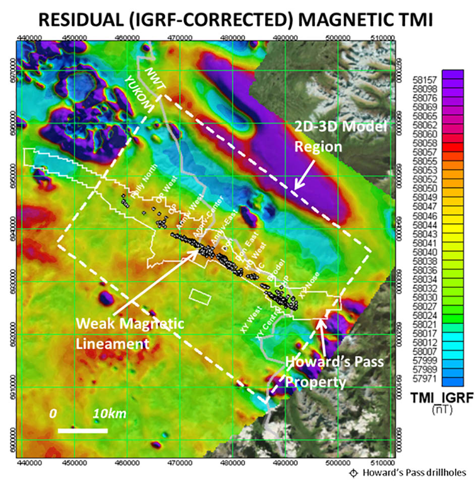
Figure 4: Residual (IGRF-corrected) total magnetic intensity (TMI) over focus area at Howard’s Pass, highlighting weak magnetic lineament and HP drillholes, known deposits and 2D-3D model region discussed below.
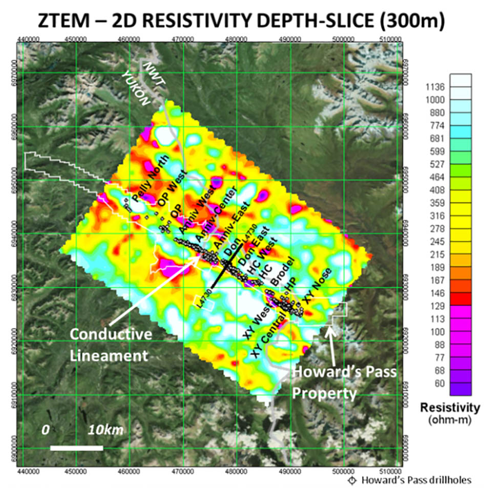
Figure 5: ZTEM™ Resistivity depth-slice (z=300m) from 2D Inversion (Tzx In-line) over detailed grid at Howard’s Pass, highlighting conductive lineament over deposits and location of L4730 model section in Fig. 7
Figure 6 compares a similar magnetic susceptibility (mag-susc.) depth-slice, obtained using UBC Mag3d (Li and Oldenburg, 1996), as the ZTEM™ resistivity image shown in Figure 5. It shows generally low mag-susc. values across the HP property which is consistent with the sedimentary host rocks. However a weak but well defined magnetic high is also seen that correlates with the south-eastern half of the HP deposit trend and ZTEM™ conductive zone and strengthens at depth. Closer examination reveals that it coincides with the southeast part of the deposit that lies in the valley at Howard’ Pass. This might be explained by enhanced hydrothermal activity or basement uplift along the HP mineralized horizon; or else, simply, slightly more susceptible pelitic and mineralized units that are exposed in the valley in contrast with very low susceptibility carbonates found in the surrounding hills.
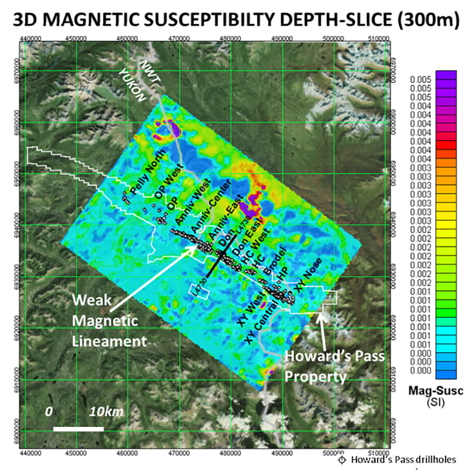
Figure 6: Magnetic susceptibility depth-slice (z=300m) from UBC 3D Inversion over detailed grid at Howard’s Pass, highlighting weak magnetic lineament over deposits and location of L4730 model section in Fig. 7.
Figure 7 compares the 3D ZTEM™ resistivity and 3D mag-susc. sections over the Don deposit, one of the largest and more deeply explored at Howard’s Pass, with many drillholes ex-tending below 800m depths, as shown in Figure 3. Figure 9a highlights the shallow buried but >500m wide resistivity low that matches the known width of the Don deposit and extends to similar depths. Resistivity highs on either side coincide with flanking carbonate units. Figure 9b shows a buried, weak but visible mag-susc. high that correlates with the deposit and extends to depth. Higher mag-susc. values at 1.5-2km depth likely reflect the deeper basement metamorphic units.
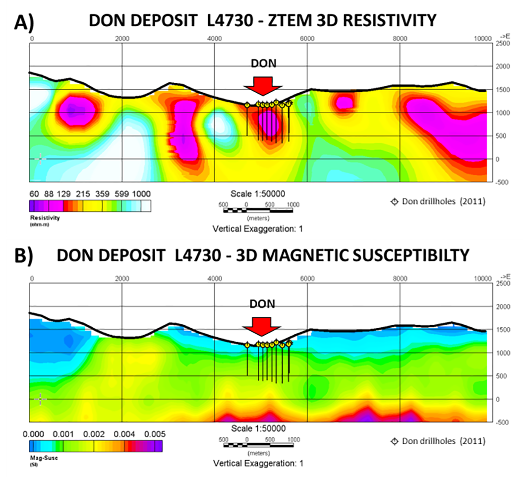
Figure 7a) ZTEM™ UBC 3D resistivity cross-section and 7b) UBC 3D Magnetic Susceptibility sections, with 2011 drillholes, showing high conductivity and slightly higher magnetic susceptibilities across deposit.
Conclusions
The ZTEM™ and magnetic results along the >37km long “zinc corridor” in the Howard’s Pass SEDEX district have been analysed at the property and deposit scale using 2D-3D computer inversion to better define their relation to geology. Their study appears to reveal a correlation be-tween enhanced conductivity along strike and the clustering of deposits at Howard’s Pass. This could be explained either by enhanced mineralization in areas of thicker black shale sub-basins or simply separation of the mineralized and shale horizons by fault-displacement.
Acknowledgements
The authors wish to thank the Yukon Geological Survey for organizing the YGS airborne geophysics workshop from which this paper originated. Our thanks to Geotech Ltd. for sponsoring this study.
References
Burgoyne, A.A., 2005, Technical evaluation report on The Howards Pass Project, Yukon-Northwest Territory border, Canada: Report (NI 43-101) for Pacifica Resources, 81 p.
Carne, R., Phillips, R., and Lane, J., 2013, An explorer’s take on the Selwyn Basin ZTEM survey: Presented at Yukon air-borne geophysics workshop, Yukon Geoscience Forum 2013, Yukon Chamber of Mines and Yukon Geological Survey, Whitehorse, Canada.
Goodfellow, W.D., 2007, Base metal metallogeny of the Selwyn Basin, Canada, in Goodfellow, W.D., ed., Mineral Deposits of Canada: A Synthesis of Major Deposit-Types, District Metallogeny, the Evolution of Geological Provinces, and Exploration Methods: Geological Association of Canada, Mineral Deposits Division, Special Publication 5, 553-579.
Holtham, E., and Oldenburg, D.W., 2008, Three-dimensional forward model and inversion of Z-TEM data: SEG Expanded Abstracts, 564-568.
Kirkham, G., Dunning, J., and Schleiss, W., 2012, Update for Don Deposit mineral resource estimate, Howard’s Pass property, eastern Yukon: NI 43-101 technical report for Selwyn Resources Ltd., 145 p.
Legault, J.M., Latrous, A., Zhao, S., Bournas, N., Plastow, G., and O’Donnell, J.J., 2014, Passive airborne EM and magnetic survey results over SEDEX lead-zinc deposits at Howard’s Pass in Selwyn Basin, Yukon, presented at36th Annual Convention, Seminar and Exhibition on Exploration Geophysics, AEG, Hyderabad, India.
Legault, J.M., Wilson G., Gribenko A., Zhdanov, M. S., Zhao, S. and Fisk, K., 2012, An overview of the ZTEM and AirMt airborne electromagnetic systems – A case study from the Nebo-Babel Ni-Cu-PGE deposit, West Musgrave, Western Australia: Preview, 158, 26-32.
Li, Y., and Oldenburg, D.W., 1996, 3-D inversion of magnetic data, Geophysics, 61, 394-408.
Lo, B., and Zang, M., 2008, Numerical modeling of Z-TEM (airborne AFMAG) responses to guide exploration strategies: SEG, Expanded Abstracts, 27, 1098-1101.
O’Donnell, J., 2009, Resource estimate report update for the Selwyn Project, Yukon-NWT, Canada: Technical report (NI 43-101) prepared for Selwyn Resources Ltd., 132 p.
Witherly, K., 2013, Report on processing of ZTEM magnetic and EM surveys, Selwyn basin area, Yukon, Canada: Yukon Geological Survey miscellaneous report MR9, 49 p.
Witherly, K, 2014, Regional airborne geophysical assessment of the Selwyn Basin area, Yukon-NWT: Presented at PDAC Prospectors and Developers Association Convention, Toronto, Canada.