Vice President of Exploration, Patricia Tirschmann states, “We’ve reached an important point in the exploration of the Maniitsoq property in that we are now identifying multiple centers of significant Ni-Cu sulphide mineralization coupled with a better understanding of the geological and structural setting as well as the nature of the mineralization and related geophysical responses. This will allow NAN to progress to the next stage of follow-up drilling using robust targeting tools to help evaluate size potential.”
In 2015, the Company continued its systematic evaluation of the Maniitsoq property, significantly expanding the existing exploration database, advancing the understanding of both the geological setting and the nature of the sulphide mineralization, refining geophysical targeting tools and continuing to intersect nickel-copper sulphide mineralization at multiple locations.
DRILLING
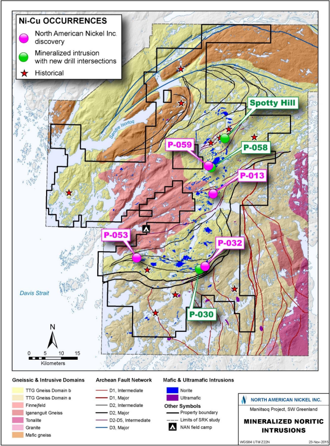
Drilling expanded the Spotty Hill zone by 80 metres in a down plunge direction (News Release dated September 2, 2015) and resulted in the intersection of additional nickel-copper sulphides at six regional exploration targets including P-013, P-030, P-032, P-053, P-058 and P-059. Four of the mineralized intrusions, P-013, P-032, P-053 and P-059, were new discoveries made by NAN. Table 1 gives a summary of selected drilling highlights for each of these mineralized areas and a location map (Figure 1) may be viewed using the link provided with this release.
For the full story and 2014 and 2105 Assay Results from Targets P-013, P-030, P-032, P-053, P-058, P-059 and Spotty Hill click here.
SULPHIDE MINERALOGY
The Maniitsoq mineralization typically consists of pyrrhotite, pentlandite, pyrite and chalcopyrite. Previous high definition mineralogical studies identified pentlandite as being the primary nickel-bearing phase hosting > 90% of the nickel and indicated potentially high nickel recoveries using convention mineral processing techniques (News Releases dated March 2, 2015 & June 11, 2013). Additional mineralized samples were collected in 2015 and recently submitted to SGS Canada Inc. of Burnaby, BC for similar analysis.
GEOLOGICAL SETTING, MAPPING AND 3D MODELLING
In July 2015, SRK Consulting (Canada) Inc. of Toronto, ON carried out a three week structural and lithological mapping program including review of 2015 drill core. This work led to a better understanding of the geological setting including the identification of a widespread sedimentary basin which was intruded by mafic to ultramafic intrusions of the Greenland Norite Belt (GNB) and later subjected to metamorphism and poly-phase deformation. These features are similar to those of the Thompson Nickel Belt.
NAN geologists completed detailed mapping over several mineralized norite intrusions in 2015. This information was used by SRK in conjunction with drilling data to carry out 3-D modeling of the deformed norites and related mineralization in order to aid in drill hole targeting and this methodology promises to be useful in future follow-up drilling.
NATURE OF MINERALIZATION AND GEOPHYSICAL RESPONSE
Maniitsoq mineralization comprises disseminated, blebby, net-textured, semi-massive and massive sulphides. Secondary structural processes have affected primary sulphides resulting in the formation of stringers, veins, fracture fillings and sulphide breccia veins. The sulphide zones are commonly represented by multiple discrete EM plates and this is interpreted to be due, at least in part, to the remobilization and disruption of primary magmatic sulphides. In 2015, step-out drilling which targeted the projected down plunge extents of mineralized zones, but not necessarily specific EM plates, continued to intersect mineralized norite.
EM methods have proven successful at identifying the higher grade, more sulphidic portions of a given zone but are not as effective at outlining the overall envelope of mineralization which can include significant accumulations of disseminated, blebby sulphides and/or less interconnected sulphides. In 2016, the company plans to carry out Induced Polarization (IP) test surveys to determine if this method is useful in defining the overall extents of mineralized zones.
EXPANDED DATABASE
The 2015 airborne survey completed the VTEM coverage over the GNB as defined on the Maniitsoq property. During the period extending from late July through to mid-September, DigitalGlobe of Longmont Colorado successfully collected high spatial resolution multi-spectral Worldview-3 satellite data across the entire property. Integrated with the Company’s other exploration datasets, this imagery provides the potential to directly target gossanous mineralization on the ground and to vastly improve on the level of mapping detail across the property.
FUTURE PLANS
In 2016, NAN plans to implement a large follow-up drilling program and continue the systematic exploration of the district scale Maniitsoq property. A key component of NAN’s evolving exploration strategy is the integration of conventional EM geophysical tools with new complementary targeting tools in order to define the extent of prospective norite stratigraphy and the full extents of mineralized zones.
Timeline
Learn how VTEM technology mapped the Maniitsoq nickel-copper-cobalt-PGM project in Southwest Greenland.
North American Nickel Maniitsoq Project Update June 2015
Helicopter surveying used at North American Nickel August 2014
