New High-Grade Manganese Find at Brumby Creek

The recently completed airborne Versatile Time-domain Electromagnetic (VTEM) survey has identified a significant area with a conductive anomaly response at the Brumby Creek Prospect.

Published: August 16, 2018

HIGHLIGHTS

  • Reconnaissance mapping and sampling in Bryah Basin identifies highgrade manganese at a new prospect named Brumby Creek.
  • High-grade manganese recorded in 19 rock chip samples:
    • 5 samples recorded +40% Mn with a highest value of 48.5% Mn, &
    • 12 samples recorded 30% – 40% Mn.
  • Outcropping manganese mineralisation at Brumby Creek has been mapped over a 2 kilometre strike length.
  • Wide zone of outcropping manganese mapped (over 100 metres wide and 250 metres long), representing an outstanding untested drill target.
  • Drilling at Brumby Creek Manganese Prospect to commence following final works approvals and site clearances

Bryah Resources Limited (“Bryah” or “the Company”) is pleased to provide an update on manganese exploration activities within its Bryah Basin Project in central Western Australia.

In March 2018, the Company announced the expansion of its Bryah Basin Project exploration programme to include manganese. Since then an extensive programme of ground reconnaissance work has been undertaken with the aim of identifying manganese outcrops and generating targets for follow-up exploration and drilling.

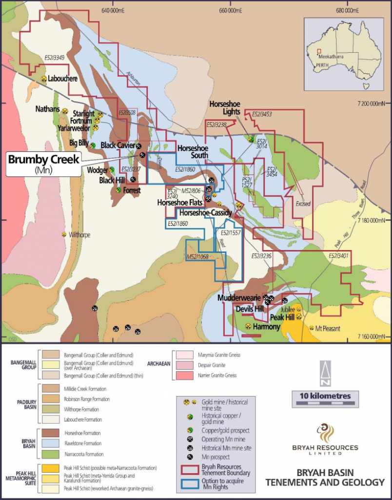
In July 2018, reconnaissance mapping focussed on an area of interest identified from satellite imagery and the recently completed airborne electromagnetic survey. Significant zones of outcropping manganese were identified in this area, which has been named Brumby Creek. The Brumby Creek prospect lies close to the Black Hill and Black Caviar prospects, where previously reported rock chips recorded grades of up to 50% Mn (see Figures 1 and 2).

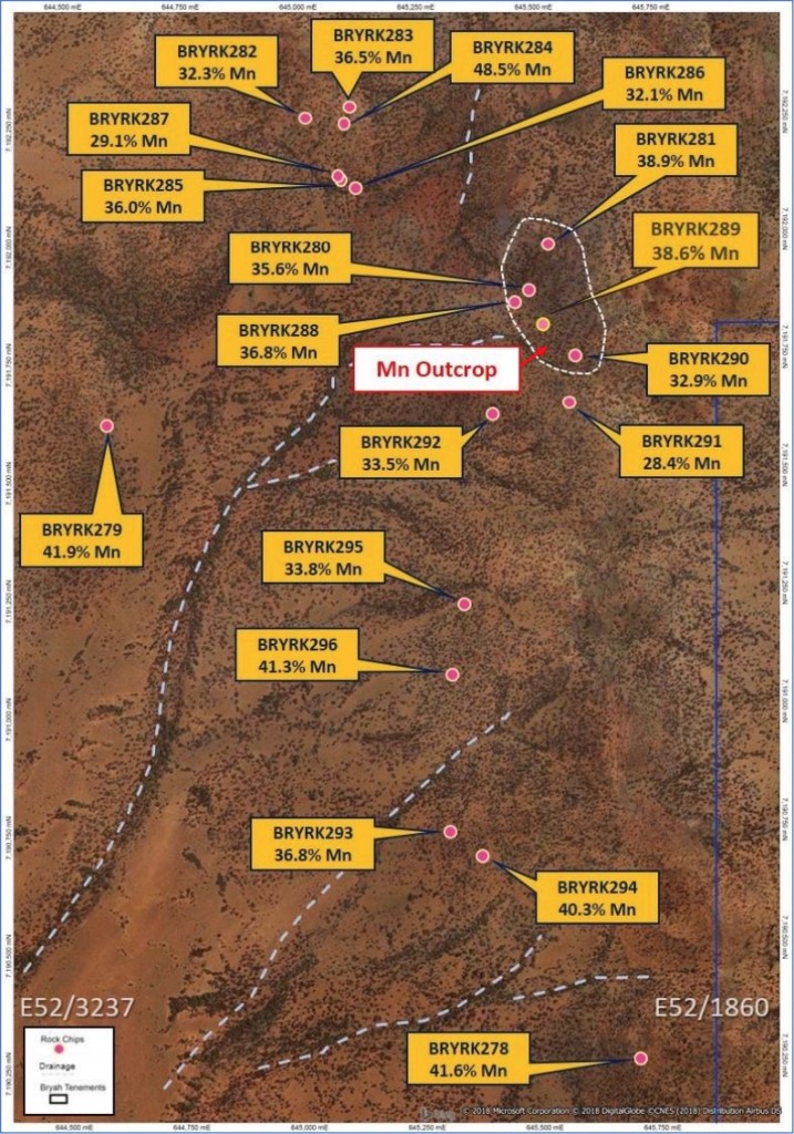
A total of 19 rock chip samples were collected from manganiferous outcrops at the Brumby Creek prospect and laboratory results from these rock chip samples have now been received. Assay results for these samples are shown in Table 1 and in Figures 3 and 4.

Of the 19 rock chip samples, 5 samples assayed above 40% Mn, including a highest value of 48.5% Mn. A further 12 samples assayed between 30% and 40% Mn. The persistent highgrade manganese recorded in these samples is very encouraging.
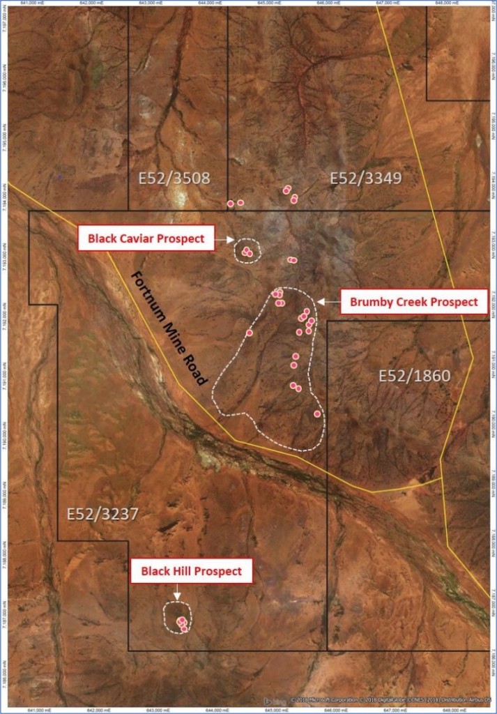
Figure 1 – Bryah Basin Tenements and Regional Geology Map

Figure 1 – Bryah Basin Tenements and Regional Geology Map

Figure 2 – Satellite imagery showing Brumby Creek and other nearby Prospects and rock chip sample points

Figure 2 – Satellite imagery showing Brumby Creek and other nearby Prospects and rock chip sample points

Local Geology

The Brumby Creek Prospect lies within the Horseshoe Formation.

The Horseshoe Formation includes finely laminated ferruginous (hematitic) shale and siltstone, fine-grained quartz–feldspar wacke with interleaved iron formation and chert, graded quartz wacke, manganiferous shale, garnetiferous biotite–chlorite schist and garnetiferous iron-formation. Relatively high manganese contents are inferred from the abundant manganese oxide staining in weathered and lateritic rocks, and lateritic manganese ore has been mined at the Horseshoe South and Mount Padbury mines.1

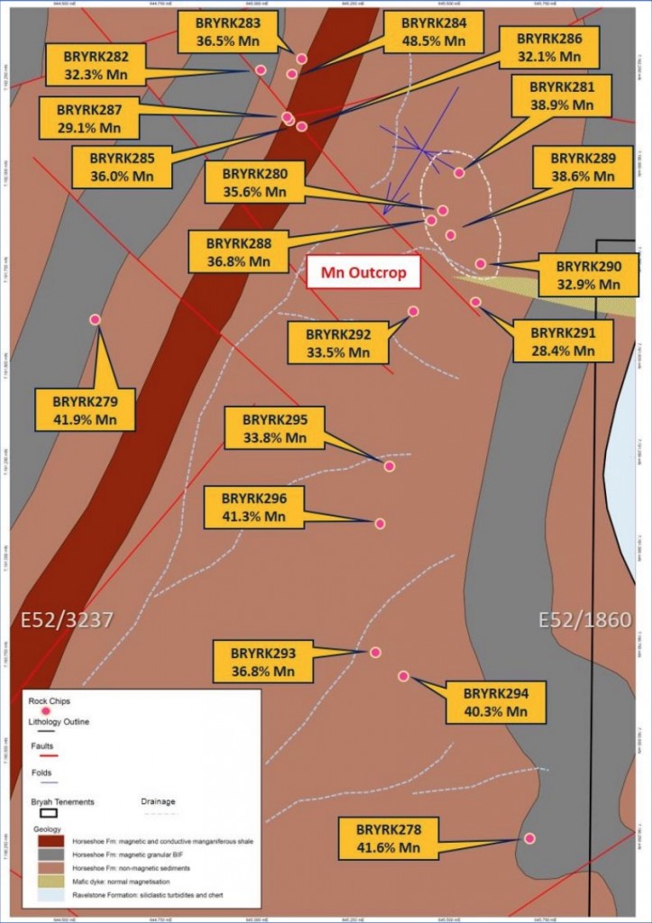
Structurally, the Horseshoe Formation in this area forms a broad syncline with its axis trending approximately southerly. Recent geophysical interpretation by Resources Potential Pty Ltd has identified a magnetic and conductive manganiferous shale unit, which is co-incident with some of the manganese outcrops sampled, including the highest recorded assay of 48.5% Mn (sample BRYRK284) (see Figure 4).

Manganese outcrops have been mapped over a strike length of 2 kilometres from BRYRK278 to BRYRK281 along the western and southern slopes of, and parallel to, the top of the Horseshoe Range.

Coincidently, the largest area of outcropping manganese identified to date by the Company occurs at the northern end of this 2 kilometres strike and covers an area over 100 metres wide and 250 metres long (see Figures 2-5 and Plate 1). This area of outcropping manganese represents an outstanding untested drill target.

VTEM Survey

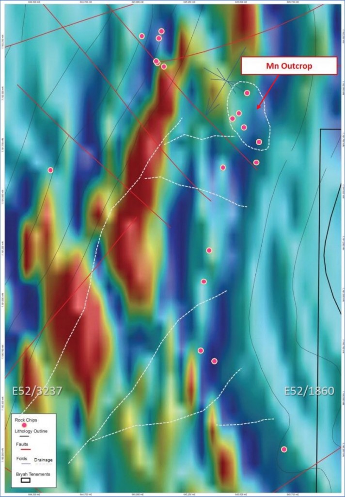
The recently completed airborne Versatile Time-domain Electromagnetic (VTEM) survey has identified a significant area with a conductive anomaly response at the Brumby Creek Prospect. The conductive anomaly appears to lie along the axis of the Horseshoe Formation syncline, adjacent to the manganiferous shale unit and generally coincides with the alignment of the creek at the base of a broad valley (see Figure 5).

The conductive zone is interpreted to be caused by geologically young scree deposits, which have potential for containing detrital manganese style mineralisation down slope from outcropping manganese occurrences and sits along the edge of a more conductive paleochannel to the west.

A drilling programme to test this conductive anomaly has been approved by the Department of Mines, Industry Regulation and Safety (DMIRS).
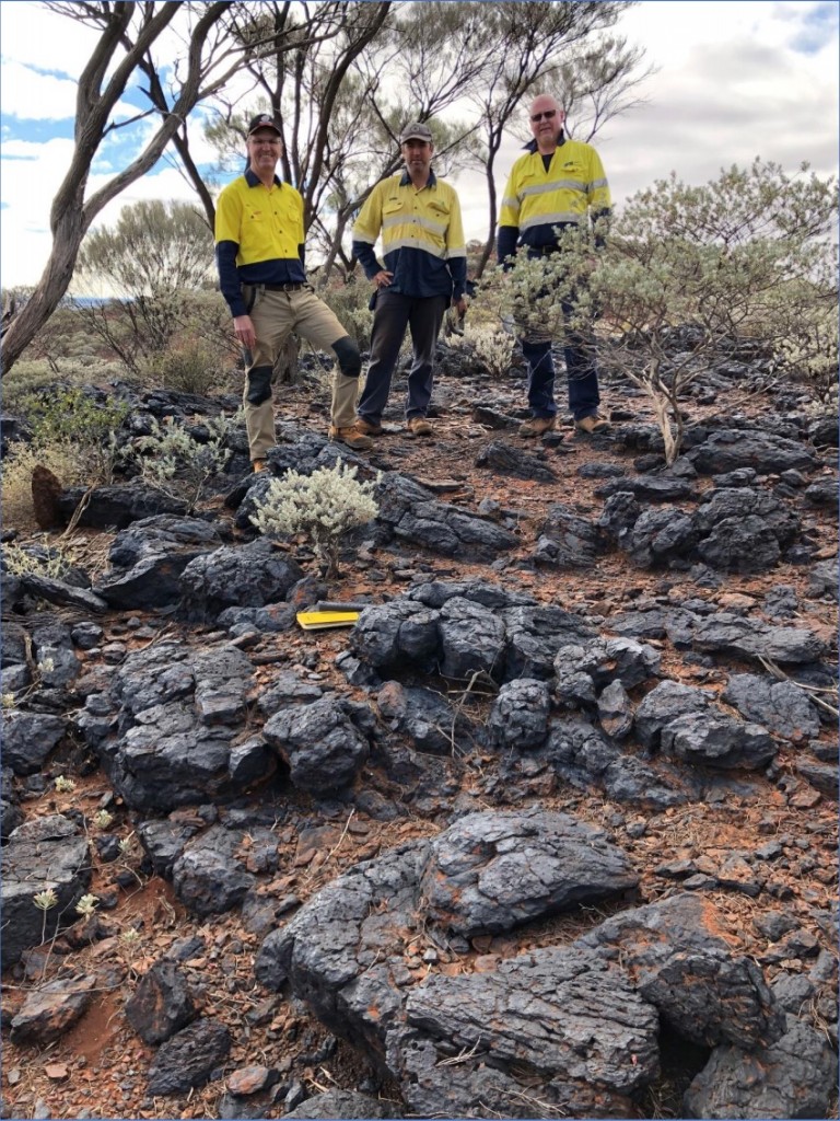
Figure 3 – Satellite imagery showing Brumby Creek Prospect, sample locations and results.

Figure 3 – Satellite imagery showing Brumby Creek Prospect, sample locations and results.

Figure 4 – Brumby Creek Prospect Interpreted Geology showing sample locations and results.

Figure 4 – Brumby Creek Prospect Interpreted Geology showing sample locations and results.

Figure 5 – VTEM Imagery (VTEM18_BFz_Ch28_1vd_psc_ne) showing Brumby Creek Prospect

Figure 5 – VTEM Imagery (VTEM18_BFz_Ch28_1vd_psc_ne) showing Brumby Creek Prospect

Neil Marston (Managing Director) with Geologists David Thompson and Lindsay Bonnett on outcropping high-grade manganese at the Brumby Creek Prospect

Plate 1 – L-R – Neil Marston (Managing Director) with Geologists David Thompson and Lindsay Bonnett on outcropping high-grade manganese at the Brumby Creek Prospect (vicinity sample BRYRK281).

Commenting on the latest results, Managing Director Neil Marston said:

“We are very excited with the latest results from this ground reconnaissance work, which highlights the benefits of having geologists methodically walking the ground and sampling. The scale and manganese grades recorded from the Brumby Creek Prospect are outstanding in our opinion, so it will be a priority target for follow-up work including drilling.

We are keen to drill for manganese at Brumby Creek as soon as possible. We also look forward to testing the various other surface targets identified by our geological team with a programme of shallow drill holes in the coming months.”

Follow-up Exploration Activities

DMIRS work approvals and site heritage clearances for drilling of manganese targets, including at Black Hill, Black Caviar, Devils Hill and parts of the Brumby Creek Prospect have now been obtained. Preparation for drilling is underway and will commence once all logistics and contracts have been finalised.

DMIRS work approvals and site heritage clearances for the remaining parts of the Brumby Creek Prospect, including the main manganese outcrop is underway. Drilling activities will commence as soon as practicable after access approvals are obtained for these areas.

For Further Information, please contact

Neil Marston
Managing Director
Tel: +618 9321 0001

Table 1 – Bryah Basin Project Manganese Samples – Laboratory Results

Sample ID Northing mN Easting mE Mn % Fe % Al2O3 % SiO2 % P %
BRYRK278 7190258 645696 41.60 8.11 7.69 5.39 0.07
BRYRK279 7191611 644567 41.93 9.27 7.13 4.7 0.04
BRYRK280 7191889 645480 35.60 11.21 10.63 7.38 0.06
BRYRK281 7191981 645520 38.85 7.85 9.76 7.63 0.04
BRYRK282 7192260 645007 32.25 20.31 5.39 4.51 0.15
BRYRK283 7192284 645100 36.52 13.34 7.75 5.68 0.11
BRYRK284 7192245 645090 48.52 6.75 3.66 2.07 0.09
BRYRK285 7192125 645078 36.04 14.47 8.29 4.49 0.12
BRYRK286 7192113 645107 32.09 19.79 6.51 3.51 0.12
BRYRK287 7192129 645078 29.11 23.19 6.66 3.45 0.18
BRYRK288 7191858 645442 39.46 8.52 8.65 7.05 0.02
BRYRK289 7191817 645495 38.60 15.89 4.12 3.53 0.10
BRYRK290 7191746 645571 32.90 18.49 6.57 3.89 0.08
BRYRK291 7191653 645559 28.41 18.45 4.65 14.59 0.18
BRYRK292 7191619 645398 33.46 18.63 6.95 3.09 0.22
BRYRK293 7190738 645293 36.81 14.70 6.98 3.38 0.09
BRYRK294 7190685 645363 40.32 12.09 6.1 3.46 0.10
BRYRK295 7191225 645329 33.83 20.42 3.98 3.44 0.24
BRYRK296 7191070 645304 41.34 10.37 5.83 4.41 0.16

 About Bryah Resources Limited

In October 2017 Bryah Resources Limited was admitted to the official list on the Australian Securities Exchange (ASX). The Company is a copper-gold-manganese focused explorer with 2 projects located in central Western Australia, being the 720 km2 Bryah Basin Project and the 202km2 Gabanintha Project. In addition, the Company holds a one year option to acquire the historic Horseshoe South Manganese Mine and the Manganese mineral rights over a further 154km2 of ground in the Bryah Basin.

The Bryah Basin is host to the high-grade copper-gold mines at DeGrussa, discovered by Sandfire Resources NL in 2009, and at Horseshoe Lights, which was mined up until 1994. The Bryah Basin also has several historical and current manganese mines.

Bryah Resources Limited’s copper-gold exploration strategy is:

  • to apply the best and latest exploration methods to evaluate the ground;
  • to use high resolution geophysics to identify deeper structures and potentially mineralised zones, and
  • to drill test targets below the depth of previous drilling.

At Gabanintha, Bryah holds the rights to all minerals except Vanadium/Uranium/Cobalt/Chromium/ Titanium/Lithium/Tantalum/Manganese & Iron Ore (Excluded Minerals). Australian Vanadium Limited retains 100% rights in the Excluded Minerals on the Gabanintha Project.

Competent Persons Statement

The information in this announcement that relates to Exploration Results is based on information compiled by Mr Rohan Williams, who is a Member of the Australasian Institute of Mining and Metallurgy. Mr Williams is an employee of Bryah Resources Limited (“the Company”). Rohan Williams has sufficient experience which is relevant to the style of mineralisation and type of deposit under consideration and to the activity which he is undertaking to qualify as a Competent Person as defined in the 2012 Edition of the ‘Australasian Code for Reporting of Exploration Results, Mineral Resources and Ore Reserves’. Rohan Williams consents to the inclusion in this announcement of the matters based on his information in the form and context in which it appears.

Forward Looking Statements

This report may contain certain “forward-looking statements” which may not have been based solely on historical facts, but rather may be based on the Company’s current expectations about future events and results. Where the Company expresses or implies an expectation or belief as to future events or results, such expectation or belief is expressed in good faith and believed to have a reasonable basis. However, forward looking statements are subject to risks, uncertainties, assumptions and other factors which could cause actual results to differ materially from future results expressed, projected or implied by such forward-looking statements. Readers should not place undue reliance on forward looking information. The Company does not undertake any obligation to release publicly any revisions to any “forward looking statement” to reflect events or circumstances after the date of this report, or to reflect the occurrence of unanticipated events, except as may be required under applicable securities laws.

Manganese Exploration and Sampling

JORC Code, 2012 Edition – Table 1 Exploration Results

Section 1 Sampling Techniques and Data

Criteria JORC Code explanation Commentary
Sampling techniques
  • Nature and quality of sampling (e.g. cut channels, random chips, or specific specialised industry standard measurement tools appropriate to the minerals under investigation, such as down hole gamma sondes, or handheld XRF instruments, etc). These examples should not be taken as limiting the broad meaning of sampling.
  • Include reference to measures taken to ensure sample representivity and the appropriate calibration of any measurement tools or systems used.
  • Aspects of the determination of mineralisation that are Material to the Public Report.
  • In cases where ‘industry standard’ work has been done this would be relatively simple (e.g. ‘reversecirculation drilling was used to obtain 1 m samples from which 3 kg was pulverised to produce a 30 g charge for fire assay’). In other cases, more explanation may be required, such as where there is coarse gold that has inherent sampling problems. Unusual commodities or mineralisation types (e.g. submarine nodules) may warrant disclosure of detailed information.
  • Rock samples were collected with sample sizes of between 2kg and 5kg from recorded locations.
Drilling techniques
  • Drill type (e.g. core, reverse circulation, open-hole hammer, rotary air blast, auger, Bangka, sonic, etc) and details (e.g. core diameter, triple or standard tube, depth of diamond tails, face-sampling bit or other type, whether core is oriented and if so, by what method, etc).
  • No drilling undertaken in this programme.
Drill sample recovery
  • Method of recording and assessing core and chip sample recoveries and results assessed.
  • Measures taken to maximise sample recovery and ensure representative nature of the samples.
  • Whether a relationship exists between sample recovery and grade and whether sample bias may haveoccurred due to preferential loss/gain of fine/coarse material.
  • No drilling undertaken in this programme.
Logging
  • Whether core and chip samples have been geologically and geotechnically logged to a level of detail to support appropriate Mineral Resource estimation, mining studies and metallurgical studies.
  • Whether logging is qualitative or quantitative in nature. Core (or costean, channel, etc) photography.
  • The total length and percentage of the relevant intersections logged.
  • No drilling undertaken in this programme.
Sub-sampling techniques and sample preparation
  • If core, whether cut or sawn and whether quarter, half or all core taken.
  • If non-core, whether riffled, tube sampled, rotary split, etc and whether sampled wet or dry.
  • For all sample types, the nature, quality and appropriateness of the sample preparation technique.
  • Quality control procedures adopted for all sub-sampling stages to maximise representivity of samples.
  • Measures taken to ensure that the sampling is representative of the in-situ material collected, includingfor instance results for field duplicate/second-half sampling.
  • Whether sample sizes are appropriate to the grain size of the material being sampled.
  • The sample sizes are considered appropriate to correctly represent the surface manganese mineralisation.
Quality of assay data and laboratory tests
  • The nature, quality and appropriateness of the assaying and laboratory procedures used and whether the technique is considered partial or total.
  • For geophysical tools, spectrometers, handheld XRF instruments, etc, the parameters used in determining the analysis including instrument make and model, reading times, calibrations factors applied and their derivation, etc.
  • Nature of quality control procedures adopted (e.g. standards, blanks, duplicates, external laboratory checks) and whether acceptable levels of accuracy (i.e. lack of bias) and precision have been established.
  • Laboratory checks and samples containing standards were included in the analyses.
Verification of sampling and assaying
  • The verification of significant intersections by either independent or alternative company personnel.
  • The use of twinned holes.
  • Documentation of primary data, data entry procedures, data verification, data storage (physical andelectronic) protocols.
  • Discuss any adjustment to assay data.
  • No drilling undertaken in this programme.
Location of data points
  • Accuracy and quality of surveys used to locate drill holes (collar and down-hole surveys), trenches, mine workings and other locations used in Mineral Resource estimation.
  • Specification of the grid system used.
  • Quality and adequacy of topographic control.
  • All sample locations were located by the Field Geologist using a conventional hand-held GPS.
  • The grid system for the Bryah Project is MGA_GDA94 Zone 50.
Data spacing and distribution
  • Data spacing for reporting of Exploration Results.
  • Whether the data spacing and distribution is sufficient to establish the degree of geological and gradecontinuity appropriate for the Mineral Resource and Ore Reserve estimation procedure(s) andclassifications applied.
  • Whether sample compositing has been applied.
  • As this programme was a reconnaissance programme the sample results are indicative in nature and are not necessarily representative of the surrounding geology.
  • Outcrop samples were not composited.
Orientation of data in relation to geological structure
  • Whether the orientation of sampling achieves unbiased sampling of possible structures and the extent to which this is known, considering the deposit type.
  • If the relationship between the drilling orientation and the orientation of key mineralised structures is considered to have introduced a sampling bias, this should be assessed and reported if material.
  • No drilling undertaken in this programme, so the relationship of samples collected to geological structures is not known.
Sample security
  • The measures taken to ensure sample security.
  • The samples collected were placed in calico bags and transported to the relevant Perth laboratory by courier.
  • Sample security was not considered a significant risk.
Audits or reviews
  • The results of any audits or reviews of sampling techniques and data.
  • The Company database has been compiled from primary data by independent database consultants and was based on original assay data and historical database compilations.
  • A regular review of the data and sampling techniques is carried out internally.

 Section 2 Reporting of Exploration Results

(Criteria listed in the preceding section also apply to this section.)

Criteria JORC Code explanation Commentary
Mineral tenement and land tenure status
  • Type, reference name/number, location and ownership including agreements or material issues with third parties such as joint ventures, partnerships, overriding royalties, native title interests, historical sites, wilderness or national park and environmental settings.
  • The security of the tenure held at the time of reporting along with any known impediments to obtaining a licence to operate in the area.
  • The relevant tenement (E52/3237) is 100% owned by Bryah Resources Limited.
  • At the time of reporting, there are no known impediments to obtaining a licence to operate in the area and the tenement is in good standing.
Exploration done by other parties
  • Acknowledgment and appraisal of exploration by other parties.
  • The manganese deposits in the region were discovered during the gold rush period between 1897 and 1911 however were of little interest to explorers at the time.
  • Mining operations between 1948 and 1967 received the focus of early exploration.
  • Manganese exploration conducted by BHP Limited, King Mining Corporation Ltd, Valiant Consolidated Ltd and various others since the 1960’s was concentrated mainly around the historic pits at Elsa Group, Millidie, Horseshoe South, Mudderwearie and Ravelstone.
  • Tuart Resources Limited and Peak Hill Manganese Pty Ltd undertook regional exploration over a large portion of the Bryah and Padbury Basins in the period after 2000, identifying numerous manganese anomalies from satellite imagery and aerial photography. Only limited on-ground exploration of many of these anomalies was undertaken.
Geology
  • Deposit type, geological setting and style of mineralisation.
  • These manganese occurrences are within the Lower Proterozoic Bryah and Padbury Basins. Manganese deposits are a product of prolonged weathering and oxidation of sedimentary rocks and chemical concentration and re-deposition of manganese within ancient drainage systems. Most of the manganese deposits are remnants of former drainage palaeochannels. Although detailed surveys have not been completed, the location of most manganese deposits appears to be at about the elevation of the former palaeosurface. These deposits are now left as hilltop mesas or cappings (inverted relief).
Drill hole Information
  • A summary of all information material to the understanding of the exploration results including a tabulation of the following information for all Material drill holes:
    • easting and northing of the drill hole collar
    • elevation or RL (Reduced Level – elevation above sea level in metres) of the drill hole collar
    • dip and azimuth of the hole
    • down hole length and interception depth
    • holelength.
  • If the exclusion of this information is justified on the basis that the information is not Material and this exclusion does not detract from the understanding of the report, the Competent Person should clearly explain why this is the case.
  • No drilling undertaken in this programme.
Data aggregation methods
  • In reporting Exploration Results, weighting averaging techniques, maximum and/or minimum grade truncations (e.g. cutting of high grades) and cut-off grades are usually Material and should be stated.
  • Where aggregate intercepts incorporate short lengths of high grade results and longer lengths of lowgrade results, the procedure used for such aggregation should be stated and some typical examples of such aggregations should be shown in detail.
  • The assumptions used for any reporting of metal equivalent values should be clearly stated.
  • No high-grade cuts have been applied to the reporting of exploration results.
  • No metal equivalent values have been used.
Relationship between mineralisation widths and intercept lengths
  • These relationships are particularly important in the reporting of Exploration Results.
  • If the geometry of the mineralisation with respect to the drill hole angle is known, its nature should bereported.
  • If it is not known and only the down hole lengths are reported, there should be a clear statement to thiseffect (e.g. ‘down hole length, true width not known’).
  • As this programme was a limited programme of reconnaissance sampling no relationships can be established.
Diagrams
  • Appropriate maps and sections (with scales) and tabulations of intercepts should be included for any significant discovery being reported These should include, but not be limited to a plan view of drill hole collar locations and appropriate sectional views.
  • See attached figures within this announcement.
Balanced reporting
  • Where comprehensive reporting of all Exploration Results is not practicable, representative reporting of both low and high grades and/or widths should be practiced to avoid misleading reporting of Exploration Results.
  • All results are reported without any cut-off grades.
Other substantive exploration data
  • Other exploration data, if meaningful and material, should be reported including (but not limited to): geological observations; geophysical survey results; geochemical survey results; bulk samples – size and method of treatment; metallurgical test results; bulk density, groundwater, geotechnical and rock characteristics; potential deleterious or contaminating substances.
  • No other exploration data available.
Further work
  • The nature and scale of planned further work (e.g. tests for lateral extensions or depth extensions or large-scale step-out drilling).
  • Diagrams clearly highlighting the areas of possible extensions, including the main geological interpretations and future drilling areas, provided this information is not commercially sensitive.
  • Drilling has been planned by the Company but not undertaken to date.


1 GSWA Report 59 – Geology and Mineralization of the Palaeoproterozoic Bryah and Padbury Basins Western Australia, by F. Pirajno, S. A. Occhipinti, and C. P. Swager, 2000

For the full press release click here.
Category: News Story

You Might Also Be Interested In

Bayhorse Silver Receives Two Silver Exploration Targets From Additional Magnetic Survey Analysis On Its Bayhorse Properties.

Bayhorse Silver Inc, has received from Geotech its magnetic structural interpretations and structural complexity analysis of its recent survey from the Bayhorse Idaho/Oregon Geophysics Project area.

Category: News Story