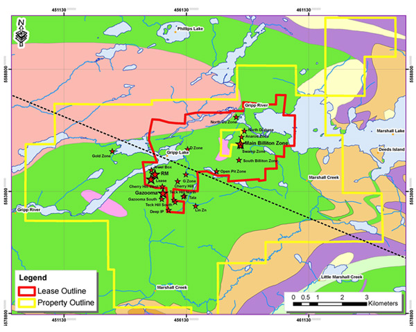
The updated 43-101 report incorporates re-interpretation of the Marshall Lake area bringing together numerous historic interpretations, government mapping, regional geophysics, and historical detailed geophysics. This process has enabled the Company to formulate a coherent fully integrated geological model of the numerous mineral occurrences located on the Marshall Lake property.
The new geological interpretation indicates additional exploration potential along strike and/or down dip from previously explored mineralization. As part of this undertaking, the correlation of the various mineralized zones to a single stratigraphic horizon brings a new understanding to the conductors identified from the historical electromagnetic surveys. The seven high potential VTEM anomalies represent the most obvious targets near known copper stringer mineralization that require further testing.
The report highlights a number of exploration targets that need to be re-examined and supports the continued development of new exploration targets. It is now recommended that a thorough compilation of all historical data is completed and a review of the geophysical and geological targets. The objective of this compilation and review is to define additional targets for follow-up and potential drill testing.
Grab sample results from the May 2016 site visit collected from the Main (Billiton) Zone included:
- Sample P240501 – 3.06% Cu, 2.00% Zn, 193g/t Ag and 1.29 g/t Au
- Sample P240502 – 3.64% Cu, 6.25% Zn, 190g/t Ag and 0.49 g/t Au
- Sample P240504 – 0.14% Cu, 0.35% Zn, 52g/t Ag and 1.13 g/t Au
The 43-101 recommends a program of exploration consisting of 4 phases. The first three phases are budgeted at $1,200,000 and include the following:
- The conductive anomalies identified from the Geotech survey are recommended for EM plate modelling and ground truthing;
- The anomalies identified by each IP/Resistivity inversion block should be compared to available drill results to determine if each anomaly was drill tested followed by ground truthing;
- The entire drill hole database for the Marshall Lake property to be fully updated and digitized;
- Surface exposures be mapped and sampled in detail to aid in the understanding of controls on mineralization;
- A systematic review and prioritization of all targets with the objective of identifying the top 3-8 exploration targets for the development of a test drilling campaign of 5-8 holes. Electromagnetic borehole surveying should be completed to aid in the improvement of the three-dimensional understanding of the mineralization.
- Review of the gold potential of the system in light of the identification of historical and newly sampled gold mineralized structures.
The SEDAR filed NI 43-101 report is dated June 7, 2016 and was prepared for the Company by Thomas Hart, P.Geo who is acting as the Company’s Qualified Person (“QP”).
About Copper Lake Resources
Copper Lake Resources Ltd. is a publicly traded Canadian company currently focused on advancing two significant properties located in Ontario, Canada:
- The Marshall Lake VMS copper, zinc, silver and gold property is an advanced exploration stage property located 120 km north of Geraldton, Ontario via good all weather gravel road from the Trans-Canada Highway and just 22 km north of the main CNR rail line.Upon completion of the previously announced transaction, Copper Lake will have a 68.75% interest in the property and will have the option to increase its interest to 75% by incurring additional expenditures of $920,000 by July 15, 2017, and can further increase its interest to 87.5% by taking the project to bankable feasibility stage.
- The Norton Lake nickel, copper, PGM property (69.79%) is located approximately 100 km north of the Marshall Lake property.
Read the press release here.
Timeline
Copper Lake Extends Earn-In Option on Marshall Lake VMS Property July 16, 2015
Copper Lake Resources Ltd.: Significant VTEM Anomalies Signal Potential for VMS Discoveries on Marshall Lake Property July 9, 2015
