Drill Hole WMA035:
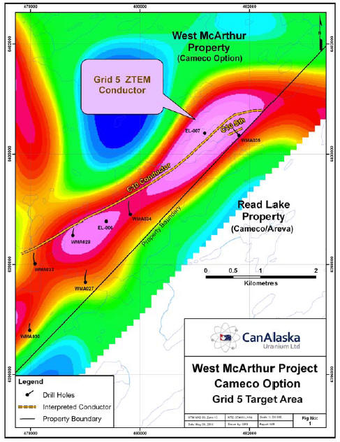
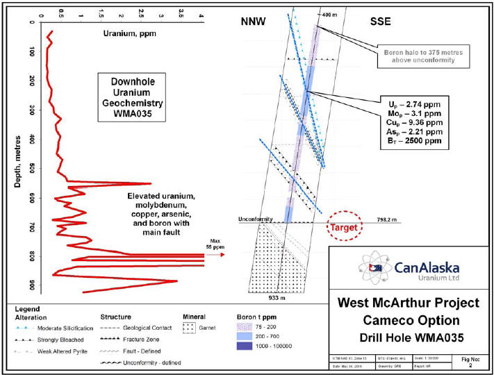
Three significant south-southeast dipping fault zones were intersected in the sandstone of the C10 South structure, see figures 1 and 2. These faults are characterized by broken core, quartz dissolution, clay healed breccias, core loss, and localized sandy-clay gouge. The sandstone in and around these fault zones is bleached with weak sooty pyrite and structurally controlled clay. The main fault strand, is associated with pervasive silicification and elevated uranium as halos about fault zones.
A broad boron anomaly from unconformity to 375 metres above is evident in the sandstone column, associated with dravite and again in the main fault.
The drill hole intersected elevated uranium in the sandstone, with locally, uranium (2.74 ppm), molybdenum (3.1 ppm), copper (9.36 ppm), arsenic (2.21 ppm), and 2,500 ppm boron. The drill hole appears to have overshot the target zone. (See figure 2 map below).
The West McArthur Uranium Project covers 35,830 hectares (88,536 acres) commencing 6 kilometres (4 miles) northwest of Cameco’s majority owned McArthur River uranium mine. Importantly, the Project is immediately adjacent to Cameco’s recently disclosed Fox Lake uranium discovery with reported inferred resources of approximately 68.1 million pounds based on 387,000 tonnes at 7.99% U3O8. The Fox Lake discovery is within the Read Lake project operated by Cameco (Cameco 78.2%, Areva 21.8%) .
The Grid 5 target is believed to host the western continuation of the C10 and C10 South conductors being explored by Cameco nearby on the Fox Lake deposit trend. The first drill hole, WMA035, is 600 metres east of historical drill hole EL-007 which was drilled in 1989 and this has strongly silicified and altered rock in the upper 400 metres of the sandstone column. The alteration and structures in the latest drill hole are similar to the alteration and structures intersected in the historical drill hole. The fault structure controlling the Fox Lake high-grade uranium mineral trend is related to the C10 conductor. The figure 2 map below shows a ZTEM anomaly along the northeastern end of the Grid 5 conductor, and the C10 and C10 south conductors, the focus of the current drill program.
CanAlaska president Peter Dasler comments,
“We are very pleased with the structural interpretation and alteration mineralogy in this first hole. The fault zones are characterized by localized sandy-clay gouge, broken core, fracture controlled clay, weak sooty pyrite and moderate to locally strong quartz dissolution. We now have evidence of a very large mineral system extending from hole WMA028 to WMA035, a distance of 3.5 kilometres. We are eagerly awaiting the restart of drilling program scheduled for early June, and feel very confident that Cameco’s staff will be able to test the structures”.
Check out our ZTEM™ brochure here.
Check out our primer on ZTEM airborne EM technology.
Read the press release here.

