Published: August 27, 2018
- New robust EM anomaly identified with similar target area to the flagship 834,000oz Julie mineral system (Eve target)Coincides with geochemical anomalism. Never drilled
- Very prominent EM anomaly at Julie also shows a strong northwest trending componentConsistent with recent re-interpretation of local structural controls which indicated that mineralisation remains largely untested downplunge to northwest
- Status of several other targets enhanced by strong spatial association between identified mineralisation and zones of ‘low’ EM response
- EM supported anomalies will provide high-priority drivers for exploration and resource growth in the new field season
West African gold explorer and developer, Azumah Resources Ltd (ASX: AZM) (‘Azumah’), advises that a recently completed VTEM (electromagnetic) geophysical survey over the Wa East camp has identified several new robust targets that will provide high-priority drivers for exploration and resource growth in this region during the coming exploration season (Fig. 1).
The 247km2 , 822-line kilometre heli-borne suvey has identified a major new target, named Eve, on the western edge of the Julie West licence. It is closely associated with the intersection of a regionally prominent, northwest-trending splay off the Baayiri Fault and a major northeast trending Tarkwaian structure. Minimal but strongly anomalous geochemical sampling supports the EM target but no drilling has been undertaken in this general area.
Encourgingly, the EM response that delineates Eve is of similar scale and intensity to the one which encompasses the flagship 834,000oz Julie mineralised system (refer Table 2).
At Julie, in addition to the strong response over the Julie mineralisation itself, there is a previously unrecognised very prominent structural component that extends for several kilometres northwest away from the drill-defined resources.
This very interesting development is supported by findings of a recent structural reinterpretation of the east-west trending Julie deposit that independently inferred that there may also exist a northwest plunging vector to mineralisation at the system scale. This new proximal zone has never been drilled.
Azumah Managing Director Stephen Stone said “This recently completed EM geophysical survey, recent and historical drilling results plus several untested high-tenor geochemical targets adds further credibility to the emergence of the Wa East region into a prominent West Africa mining camp in its own right”.
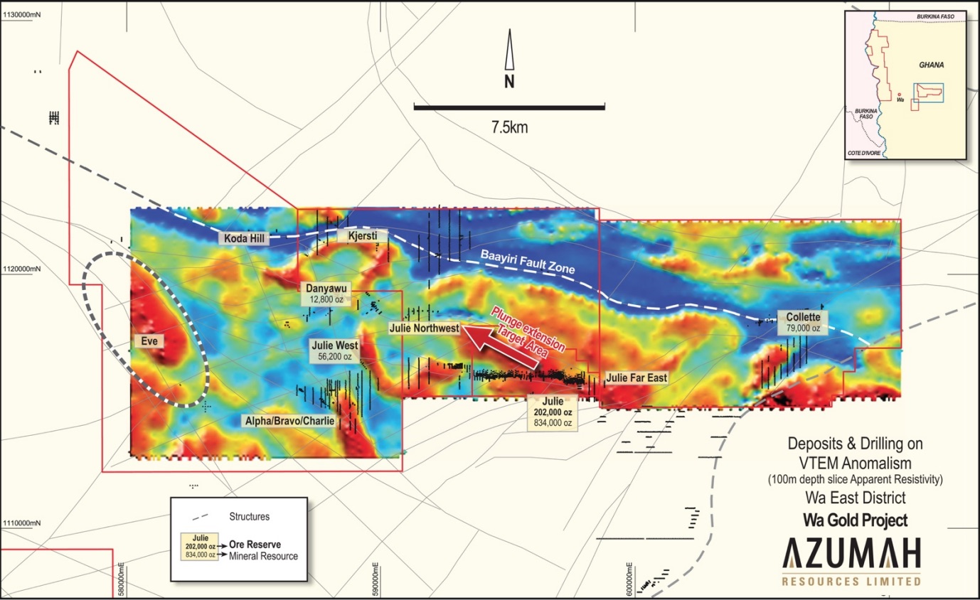
Fig 1: Wa East VTEM geophysical survey image over key deposits, prospects and drilling
(Note the large undrilled Eve EM anomaly and the previously unrecognised northwest plunging vector to the large EM anomaly over the drill-defined east-west Julie mineralised system)
The EM data has also revealed a strong spatial association between known mineralisation and ‘low, late-time’ EM responses across the broader Wa East project area. This highlighted relationship will provide a useful tool for the mapping of potentially mineralised rock volumes.
Of immediate relevance is that this demonstrated relationship indicates that the Kjersti and Danyawu prospects are most likely part of the same mineralised system, the majority of which remains untested by drilling.
Comment
These latest developments in exploration validate the view of the Azumah-Ibaera joint venture that considerably more mineralisation could be identified in and around existing deposits and prospects (refer ASX release dated 20th August 2018).
Survey notes
The helicopter-borne programme comprised a versatile, time domain, electromagnetic system (VTEM), a horizontal magnetic gradiometer (magnetics) and a gamma-ray spectrometer (radiometrics). It was flown in April-May 2018 by Canadian firm, Geotech Airborne Geophysical Surveys.
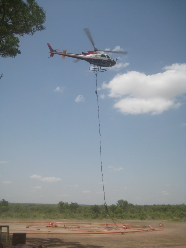
Geotech helicopter preparing to commence survey with transmitter-receiver suspended below
For further information please contact:
Stephen Stone
Managing Director
Mb 61 (0) 418 804 564
stone@azumahresources.com.au
Peter Harris
Peter Harris & Associates
Mb 61 (0) 412 124 833
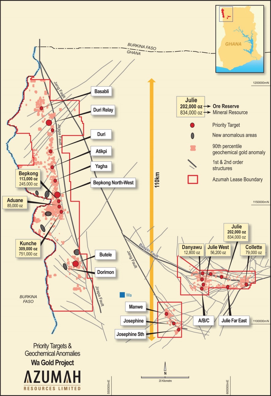
Wa Gold Project: Deposits and priority targets for 2018
About Azumah
Azumah Resources Limited is an ASX-listed (ASX: AZM) company focused on exploring and developing its regional scale Wa Gold Project in the Upper West Region of Ghana, West Africa.
Three main deposits have been discovered and extensively drilled at Kunche and Bepkong, adjacent to the Black Volta River and Ghana’s border with Burkina Faso, and at Julie ~80km to the east. Several satellite deposits, including Aduane and Collette, have also been delineated.
To date, the Company has delineated a JORC 2012 Mineral Resource of 2.1Moz of gold grading 1.5g/t Au, including 1.4Moz Measured and Indicated grading 1.7g/t Au, with these evenly distributed between Kunche-Bepkong and Wa East (Julie deposit). Within this a JORC 2012 Ore Reserve of 624,000oz Au (9.1Mt at 2.14g/t Au) has been defined.
Extensive metallurgical test work has confirmed a high average overall gold recovery of ~92% for the combined Kunche, Bepkong and Julie deposits.
Mineral Resources have been progressively grown through a focused, systematic approach to exploration of the Company’s 2,400km2 licence holdings, which encompass large tracts of prospective Birimian terrain, the rocks that host the majority of West Africa’s gold mines. Much of this is covered in soil, alluvium or laterite so most discoveries have been ‘blind’. Azumah anticipates Mineral Resources will grow substantially as it continues to test its large pipeline of target areas and specific prospects.
Azumah’s exploration strategy is primarily driven by its need to boost Mineral Resources to increase the existing Ore Reserve base from 624,000oz towards 1.0Moz. This would more solidly underpin a development decision and improve funding capability.
Azumah has two 15-year Mining Leases over its key deposits (Ghana government holds a 10% free carried interest in their ‘rights and obligations’ and is also entitled to a 5% gross gold royalty).
No technical, social or environmental impediments to development have been identified, no communities need to be relocated and rehoused and there is strong support from key stakeholders for the Project. The Project benefits from excellent regional infrastructure including grid power to site, good quality bituminised and non-bituminised roads, easy access to water, a 2km sealed airstrip at the regional centre of Wa and good general communications.
Ibaera Funding Transaction
On 1 September 2017 Azumah executed a transformative Earn-In and Shareholders Agreement (EISA) with Perth managed private equity group, Ibaera Capital GP Limited, whereby Ibaera can earn in two stages over two years up to a 47.5% direct interest in Azumah’s Wa Gold Project for an expenditure of US$13.5 million (~A$17M). The terms of the EISA set out the basis for the parties to boost Mineral Resources, Ore Reserves and to deliver a study supporting a decision to proceed to production within the next two years (refer ASX release dated 2 September 2017. Ibaera’s investment in the Project was preceded by a review of some two hundred other international resource projects and a very thorough due diligence on the Project itself over several months.
References
All references to Mineral Resources and Ore Reserves pertain to ASX releases dated 2 September 2014, 23 March 2015 and 12 October 2016 respectively. Also refer to Tables 1 and 2 herein. The Company confirms that all material assumptions underpinning the production targets and forecast information continue to apply and have not materially changed other than a positive material reduction in capital costs (refer ASX release dated 9 May 2016). For further information on Azumah Resources Limited and its Wa Gold Project please visit its website at www.azumahresources.com.au which contains copies of all continuous disclosure documents to ASX, Competent Persons’ Statements and Corporate Governance Statement and Policies.
Competent Persons’ Statements
The scientific and technical information in this report that relates to the geology of the deposits and exploration results is based on information compiled by Mr Stephen Stone, who is an executive employee of Azumah Resources Limited. Mr Stone is a Member of the Australian Institute of Mining and Metallurgy and has sufficient experience which is relevant to the style of mineralisation and type of deposit under consideration and to the activity which he is undertaking to qualify as a Competent Person as defined in the 2012 Edition of the ‘Australasian Code for Reporting of Exploration Results, Mineral Resources and Ore Reserves’. Mr Stone is the Qualified Person overseeing Azumah’s exploration projects and has reviewed and approved the disclosure of all scientific or technical information contained in this announcement that relates to the geology of the deposits and exploration results.
Table 1: Ore Reserves Summary – JORC Code 2012
| Proved | Probable | Total | Gold To Mill | ||||
|---|---|---|---|---|---|---|---|
| (As at August 2014) | Tonnes (Mt) | Grade g/t Au | Tonnes (Mt) | Grade g/t Au | Tonnes (Mt) | Grade g/t Au | Gold oz |
| Kunche | 4.91 | 1.92 | 0.05 | 3.11 | 4.97 | 1.94 | 309,000 |
| Bepkong | 1.79 | 1.84 | 0.11 | 1.97 | 1.90 | 1.85 | 113,000 |
| Julie | 0.29 | 2.45 | 1.93 | 2.89 | 2.21 | 2.84 | 202,000 |
| Total | 7.00 | 1.92 | 2.09 | 2.85 | 9.08 | 2.14 | 624,000 |
Values have been rounded.
Table 2: Mineral Resource Estimate – JORC Code 2012 – Updated October 2016
| Measured | Indicated | Inferred | Total | |||||||||
|---|---|---|---|---|---|---|---|---|---|---|---|---|
| Deposit | Tonnes (M) | Grade g/t Au | Gold oz | Tonnes (M) | Grade g/t Au | Gold oz | Tonnes (M) | Grade g/t Au | Gold oz | Tonnes (M) | Grade g/t Au | Gold oz |
| Kunche | 8.42 | 1.7 | 468,000 | 2.24 | 1.4 | 99,000 | 4.86 | 1.2 | 183,000 | 15.52 | 1.5 | 751,000 |
| Bepkong | 2.22 | 1.8 | 128,000 | 1.70 | 1.3 | 73,000 | 1.17 | 1.2 | 44,000 | 5.09 | 1.5 | 245,000 |
| Aduane | 1.77 | 1.5 | 85,000 | 1.77 | 1.5 | 85,000 | ||||||
| Julie | 0.89 | 1.4 | 41,000 | 10.06 | 1.6 | 507,000 | 5.98 | 1.5 | 286,000 | 16.93 | 1.5 | 834,000 |
| Julie West | 0.38 | 4.2 | 52,000 | 0.03 | 4.0 | 4,000 | 0.41 | 4.2 | 56,000 | |||
| Danyawu | 0.07 | 5.5 | 13,000 | 0.07 | 5.5 | 13,000 | ||||||
| Collette | 1.69 | 1.5 | 79,000 | 1.69 | 1.5 | 79,000 | ||||||
| Total | 11.52 | 1.7 | 637,000 | 14.45 | 1.6 | 744,000 | 15.50 | 1.4 | 681,000 | 41.49 | 1.5 | 2,063,000 |
Note: Values have been rounded. A lower cut-off of 0.5g/t Au was used for Kunche, Bepkong, Aduane, Julie and Collette, and a lower cut-off of 1.0g/t Au was used for Julie West and Danyawu.
Statements of Competent Persons for the various Mineral Resource Estimates, Ore Reserve Estimates and Process Metallurgy can all be found on the Company’s website at: http://www.azumahresources.com.au/projects-competent_persons.php
Forward-Looking Statement
All statements other than statements of historical fact included on this website including, without limitation, statements regarding future plans and objectives of Azumah, are forward-looking statements. Forward-looking statements can be identified by words such as ‘anticipate”, “believe”, “could”, “estimate”, “expect”, “future”, “intend”, “may”, “opportunity”, “plan”, “potential”, “project”, “seek”, “will” and other similar words that involve risks and uncertainties. These statements are based on an assessment of present economic and operating conditions, and on a number of assumptions regarding future events and actions that are expected to take place. Such forward-looking statements are not guarantees of future performance and involve known and unknown risks, uncertainties, assumptions and other important factors, many of which are beyond the control of the Company, its directors and management of Azumah that could cause Azumah’s actual results to differ materially from the results expressed or anticipated in these statements.
The Company cannot and does not give any assurance that the results, performance or achievements expressed or implied by the forward-looking statements contained on this website will actually occur and investors are cautioned not to place any reliance on these forward-looking statements. Azumah does not undertake to update or revise forward- looking statements, or to publish prospective financial information in the future, regardless of whether new information, future events or any other factors affect the information contained on this website, except where required by applicable law and stock exchange listing requirements.
Appendix: Wa Gold Project – JORC Code 2012 Edition – Table 1
Section 1 Sampling Techniques and Data
(Criteria in this section apply to all succeeding sections.)
| Criteria | JORC Code explanation | Commentary |
|---|---|---|
| Sampling techniques | Nature and quality of sampling (eg cut channels, random chips, or specific specialised industry standard measurement tools appropriate to the minerals under investigation, such as down hole gamma sondes, or handheld XRF instruments, etc). These examples should not be taken as limiting the broad meaning of sampling. | Helicopter borne geophysical survey of 776 line- kilometres completed by Geotech Airborne Geophysical Surveys in May 2018.
Survey was consisted of EM using the versatile time- domain electromagnetic (VTEM) plus system with Full-Waveform processing. |
| Include reference to measures taken to ensure sample representivity and the appropriate calibration of any measurement tools or systems used. | Data QA/QC was carried out on a daily basis during the survey. | |
| Aspects of the determination of mineralisation that are Material to the Public Report. In cases where ‘industry standard’ work has been done this would be relatively simple (eg ‘reverse circulation drilling was used to obtain 1 m samples from which 3 kg was pulverised to produce a 30 g charge for fire assay’). In other cases more explanation may be required, such as where there is coarse gold that has inherent sampling problems. Unusual commodities or mineralisation types (eg submarine nodules) may warrant disclosure of detailed information | The VTEM survey has identified targets prospective for mineralisation. The presence of mineralisation is yet to be determined.
VTEM surveys are an industry standard practise in mineral exploration. |
|
| Drilling techniques | Drill type (eg core, reverse circulation, open-hole hammer, rotary air blast, auger, Bangka, sonic, etc) and details (eg core diameter, triple or standard tube, depth of diamond tails, face- sampling bit or other type, whether core is oriented and if so, by what method, etc). | N/A |
| Drill sample recovery | Method of recording and assessing core and chip sample recoveries and results assessed. | N/A |
| Measures taken to maximise sample recovery and ensure representative nature of the samples. | N/A | |
| Whether a relationship exists between sample recovery and grade and whether sample bias may have occurred due to preferential loss/gain of fine/coarse material. | N/A | |
| Logging | Whether core and chip samples have been geologically and geotechnically logged to a level of detail to support appropriate Mineral Resources | N/A |
| Whether logging is qualitative or quantitative in nature. Core (or costean, channel, etc) photography. | N/A | |
| The total length and percentage of the relevant intersections logged. | N/A | |
| Sub- sampling techniques and sample preparation | If core, whether cut or sawn and whether quarter, half or all core taken. | N/A |
| If non-core, whether riffled, tube sampled, rotary split, etc and whether sampled wet or dry. | N/A | |
| For all sample types, the nature, quality and appropriateness of the sample preparation technique. | N/A | |
| Quality control procedures adopted for all sub-sampling stages to maximise representivity of samples. | N/A | |
| Measures taken to ensure that the sampling is representative of the in situ material collected, including for instance results for field duplicate/second-half sampling | N/A | |
| Whether sample sizes are appropriate to the grain size of the material being sampled | N/A | |
| Quality of assay data and laboratory tests | The nature, quality and appropriateness of the assaying and laboratory procedures used and whether the technique is considered partial or total. | EM measurements taken using VTEM system.
VTEM system calibrated prior to commencement of survey at standard testing sites. All digital data is inspected on a daily basis to ensure that bad data is not present and to identify missing data sections. A preliminary flight path map is plotted and checked against survey specifications. Following completion of the survey all digitally acquired survey data has been merged into a Geosoft Montaj database and checked on a line by line basis. The data presented here is preliminary data and has not undergone any processing to reduce noise or base level adjustments. However following the QA/QC completed by the contractor and the consultant they have advised that the data is suitable for public domain release and anomalism/targets for follow-up will not markedly change following final processing. |
| For geophysical tools, spectrometers, handheld XRF instruments, etc, the parameters used in determining the analysis including instrument make and model, reading times, calibrations factors applied and their derivation, etc. | Principal geophysical sensors included a versatile time domain electromagnetic (VTEMTMplus) system, horizontal magnetic gradiometer with two caesium sensors and RSI ARGS RSX-5 spectrometer. Ancillary equipment included a GPS navigation system and a radar altimeter.
Transmitter:
Receiver:
|
|
| Nature of quality control procedures adopted (eg standards, blanks, duplicates, external laboratory checks) and whether acceptable levels of accuracy (ie lack of bias) and precision have been established. | N/A | |
| Verification of sampling and assaying | The verification of significant intersections by either independent or alternative company personnel. | N/A |
| The use of twinned holes. | N/A | |
| Documentation of primary data, data entry procedures, data verification, data storage (physical and electronic) protocols. | Data is recorded using a Geotech proprietary data acquisition system. All digital data is inspected daily to ensure that bad data is not present and to identify missing data sections. A preliminary flight path map is plotted and checked against survey specifications. | |
| Discuss any adjustment to assay data. | N/A | |
| Location of data points | Accuracy and quality of surveys used to locate drill holes (collar and down-hole surveys), trenches, mine workings and other locations used in Mineral Resource estimation. | Navigation system used was Geotech PC104, utilizing a NovAtel’s WAAS enabled GPS receiver, Geotech navigate software, a full screen display in front of the pilot and a NovAtel GPS antenna mounted on the helicopter tail. |
| Specification of the grid system used. | WGS84 Zone30 North. | |
| Quality and adequacy of topographic control. | The positional accuracy is 1.8m. | |
| Data spacing and distribution | Data spacing for reporting of Exploration Results. | The survey was flown on north-south lines, spaced 200m or 400m apart, with two east-west tie lines spaced 4000m |
| Whether the data spacing and distribution is sufficient to establish the degree of geological and grade continuity appropriate for the Mineral Resource and Ore Reserve estimation procedure(s) and classifications applied. | The survey was oriented perpendicular to the major structures and lithological trends in the area. | |
| Whether sample compositing has been applied. | N/A | |
| Orientation of data in relation to geological structure | Whether the orientation of sampling achieves unbiased sampling of possible structures and the extent to which this is known, considering the deposit type. | N/A |
| If the relationship between the drilling orientation and the orientation of key mineralised structures is considered to have introduced a sampling bias, this should be assessed and reported if material. | N/A | |
| Sample security | The measures taken to ensure sample security. | All data acquired by Geotech has been reported to Azumah Resources. |
| Audits or reviews | The results of any audits or reviews of sampling techniques and data. | No independent audits have been undertaken. |
Section 2 Reporting of Exploration Results
(Criteria listed in the preceding section also apply to this section.)
| Criteria | JORC Code explanation | Commentary | ||||||||
|---|---|---|---|---|---|---|---|---|---|---|
| Mineral tenement and land tenure status | Type, reference name/number, location and ownership including agreements or material issues with third parties such as joint ventures, partnerships, overriding royalties, native title interests, historical sites, wilderness or national park and environmental settings. | The Project area is located in the Upper West Region in the north-west corner of Ghana.
All leases are held 100% by Azumah Resources Ltd (Ghana) or its wholly owned subsidiary Phoenix Resources. The VTEM survey was conducted on the following licences:
|
||||||||
| The security of the tenure held at the time of reporting along with any known impediments to obtaining a licence to operate in the area. | The tenements are in good standing with no known impediments. | |||||||||
| Exploration done by other parties | Acknowledgment and appraisal of exploration by other parties. | Previous mapping and exploration works were completed by BHP- Utah (1990’s), AGEM (late 1990’s) and Semafo (late 1990’s). All exploration activities have been completed by Azumah since 2006. | ||||||||
| Geology | Deposit type, geological setting and style of mineralisation. | The Wa Gold Project covers approximately 70% of the Palaeoproterozoic Upper and Lower Birimian units, typically known as the Wa-Lawra greenstone belt, within Ghana. Gold mineralisation at deposits within the Project occurs as follows:
Kunche: Brittle quartz lode/breccia-hosted with higher grade Au mineralisation associated with zones of intense silicification, smoky quartz veins, arsenopyrite and pyrrhotite. Bepkong and Aduane: Increased ductile shearing and dismemberment of quartz veins. Greater than 1 g/t Au mineralisation occurs within translucent quartz veins and arsenopyrite. Julie: Quartz veining and lodes within sheared granodiorite host. Au mineralisation is associated with silicification, pyrite, chalcopyrite, carbonate, sericite and haematite alteration. Collette: Quartz veining with at least 3 orientations. Au mineralisation is associated with silicification, arsenopyrite, pyrite, haematite alteration and glassy translucent quartz veining. |
||||||||
| Drill Hole Information | A summary of all information material to the understanding of the exploration results including a tabulation of the following information for all Material drill holes:
If the exclusion of this information is justified on the basis that the information is not Material and this exclusion does not detract from the understanding of the report, the Competent Person should clearly explain why this is the case.
|
N/A | ||||||||
| Data aggregation methods | In reporting Exploration Results, weighting averaging techniques, maximum and/or minimum grade truncations (eg cutting of high grades) and cut-off grades are usually Material and should be stated. | N/A | ||||||||
| Where aggregate intercepts incorporate short lengths of high grade results and longer lengths of low grade results, the procedure used for such aggregation should be stated and some typical examples of such aggregations should be shown in detail. | N/A | |||||||||
| The assumptions used for any reporting of metal equivalent values should be clearly stated. | N/A | |||||||||
| Relationship between mineralisation widths and intercept lengths | These relationships are particularly important in the reporting of Exploration Results. | N/A | ||||||||
| If the geometry of the mineralisation with respect to the drill hole angle is known, its nature should be reported.If it is not known and only the down hole lengths are reported, there should be a clear statement to this effect (eg ‘down hole length, true width not known’). | N/A | |||||||||
| Diagrams | Appropriate maps and sections (with scales) and tabulations of intercepts should be included for any significant discovery being reported. These should include, but not be limited to a plan view of drill hole collar locations and appropriate sectional views. | Refer to diagrams in body of text. | ||||||||
| Balanced reporting | Where comprehensive reporting of all Exploration Results is not practicable, representative reporting of both low and high grades and/or widths should be practiced to avoid misleading reporting of Exploration Results. | The plan in the body of the text indicates the VTEM survey area, interpreted structures and all drilled holes to date. | ||||||||
| Other substantive exploration data | Other exploration data, if meaningful and material, should be reported including (but not limited to): geological observations; geophysical survey results; geochemical survey results; bulk samples – size and method of treatment; metallurgical test results; bulk density, groundwater, geotechnical and rock characteristics; potential deleterious or contaminating substances. | All meaningful and material exploration data has been referred to in the body of the text or on accompanying figure. | ||||||||
| Further work | The nature and scale of planned further work (eg tests for lateral extensions or depth extensions or large-scale step-out drilling). | Data produced from the VTEM survey will be used in ongoing exploration.
Currently, two significant targets have been identified in the Apparent Resistivity -100m depth slice at Eve and a northwest plunge at the Julie Deposit. Mapping and geochemical sampling will be conducted here in the upcoming field season, with deep drilling being proposed. |
||||||||
| Diagrams clearly highlighting the areas of possible extensions, including the main geological interps and future drilling areas, provided not commercially sensitive. | Refer to diagrams in body of text. |
For the full press release click here.