
Presented at at SEG 2014, Denver, C0lorado, USA and KEGS-PDAC 2014, Toronto, Ontario, Canada
For a PDF of this paper click here
Summary
Airborne geophysical surveys, consisting of fixed-wing magnetic gradiometer and gamma-ray spectrometer and helicopter-borne full-waveform Versatile Time-Domain Electromagnetic (VTEM™) surveys were carried out over the Iullemmeden basin, in western Niger for mineral exploration and detailed geological mapping. The eastern portion of the basin is known to include substantial phosphate, lignite coal and iron ore deposits whereas, the western portion, which belongs to the Liptako Metallogenic Province, hosts several mineral occurrences including base and precious metals, precious stones and special metals in various deposit styles.
Geophysical data integration with other available types of information including Landsat ETM+ imagery and geological maps has been performed using innovative approaches based on Neural Networks (NN) and Enhanced Maximum Likelihood (EML) supervised classification techniques. Combined techniques have proven very useful during the analysis of multidisciplinary data resulting in better understanding of the distribution of mineralization and the results were used for targeting and selecting new favorable areas for the exploration of various mineralization styles within the study area.
Results of gamma-ray spectrometer, aeromagnetic and Landsat TM data interpretation and their integration with known geology suggest the existence of three metallogenic provinces within this area. The first two provinces are associated with tertiary sediments of the Iullemmeden basin and include potential radioactive mineralizations (uranium and thorium). The third province is associated with intrusive and metavolcanic sedimentary formations of the Birimian Liptako basement outcropping partly along the east side of the Niger River and hosting various styles of polymetallic mineralization (Cu, Pb, Zn, Ag), precious metals (gold and diamonds), special metals (Sn, W, Ta, Bi, Li, Ti), iron ore, REE and Ni-PGE mineralization.
Introduction
A fixed-wing airborne gamma-ray spectrometer and magnetic gradiometer survey was carried out over the Iullemmeden sedimentary basin, located in the western Niger in 2012-2013 covering an area of approximately 73,000 km2 for mineral exploration and detailed geological mapping. The airborne survey was flown at constant ground clearance of 100m in average along lines striking in the east-west direction and spaced at 500m apart. Three high-sensitivity cesium magnetometers were used to measure the inline and crossline horizontal gradients of the Earths’ magnetic field and a set of two NaI (Tl) gamma-ray detector-packs, each of 16L (downward looking) and 4L (upward looking) in volume were utilized to measure the natural gamma-ray radiations. The fixed-wing airborne survey was followed by detailed helicopter borne TEM surveys to collect time-domain EM and magnetic field data over several target areas.
In this paper we present the interpretation results of the acquired airborne geophysical data and their integration with the satellite imagery and the available geological information. Several data integration methods based on innovative approaches and algorithms such as color space transformation and image fusion, neural networks and supervised classifications were applied to the multidisciplinary data, resulting in a more precise lithological map of the area and accurate delineation of several new potential targets including a wide variety of mineralization styles.
Geology and Mineralization
The sedimentary series exposed in the Iullemmeden basin consist mainly of Eocene-Pliocene Continental Terminal and Quaternary formations. The Continental Terminal series which consist of marine and continental sediments host considerable amounts of phosphate-bearing, lignite coal and iron ore formations (Greigert, 1966).
The Precambrian Liptako basement formations outcrop in the western portion of the sedimentary basin and consist mainly of Birimian volcano-sediments and Proterozoic intrusive formations. Since the earliest exploration work carried out in the Liptako basement, these volcano-sediments and intrusive rocks have shown a metallogenic interest for the exploration of various mineral resources (Franconi, 1985); they host several hundred of mineralized occurrences including precious and base metals, precious stones, PGE and REE mineralizations.
Interpretation Results
Lithological mapping
A new lithological map was derived from the multidisciplinary data interpretation (Figure 1). The magnetic data were further used for mapping geological structures including faults, contacts, mafic metavolcanic formations and various types of intrusive rocks including felsic, mafic and ultramafic formations with the aim of delineating new favorable target areas for the exploration of various mineralization styles including base and precious metals, PGE, ferric metals (Fe, Ni) and iron-ore formations.
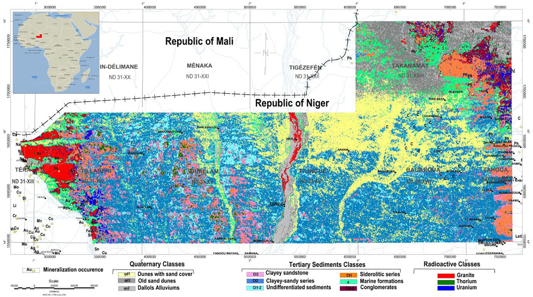
Figure 1: Predicted lithological map of the Iullemmeden basin obtained with the maximum likelihood classification algorithm including the location of the main mineralization occurences
Figure 2 illustrates the results of magnetic interpretation of the Liptako area (western portion), which shows evidence of the presence of numerous NW trending Mezo-Neoproterozoic mafic doleritic dikes intruding the Birimian basement formations and dominating the southwestern portion of the study area. The interpretation also suggests the existence of NE and NW trending faulting systems that appear to affect the doleritic dykes. The NE trending system is suggested to be associated with the major lithospheric Guinean-Nubian-Lineament (GLN). Several circular magnetic anomalies suggesting a possible link to kimberlite pipes were identified within the Liptako cratonic area (West African Craton) and along the GNL lineament in the pre-cratonic area. Mafic metavolcanics (mV) and mafic-ultramafic intrusives are identified in the western portion of the study area. The metavolcanics occur either as sandwiched between two NE trending faults or as folded formations and affected by NW trending faults. Most of gold deposits known in the Liptako Metallogenic Province are associated with shear-zone hosted tectonic traps within the volcano-sedimentary formations of the Birimian green stone belt.
Supervised clustering and targeting techniques have been extensively used and applied to the radiometric, the magnetic and the Landsat ETM+ data for detailed geological mapping and delineation of new mineralized target areas.
Mapping granite intrusives
Granite intrusives and pegmatite dikes known to host several tin and tungsten mineralized zones are delineated with the magnetic and radiometric data; they are associated with magnetic lows and highly radioactive levels. Furthermore, elevated potassium concentration and elevated potassium to thorium ratios coincide with mineralized young intrusives and alkaline rocks. Unexposed Birimian volcano-sedimentary formations that host several mineralization styles including copper, gold and tin mineralization are accurately delineated due to their low radioactivity response and moderate magnetic signature.
Detecting radioactive minerals
The spectrometer data were very helpful for mapping and delineating highly radioactive anomalous zones associated with uranium and thorium mineralization of economic interest. The detected uranium anomalous zones exhibit elevated equivalent uranium concentrations and high uranium to thorium ratios; they are associated with highly altered and mineralized tertiary sandstones and conglomerates within the Upper series of the Continental Terminal formations.
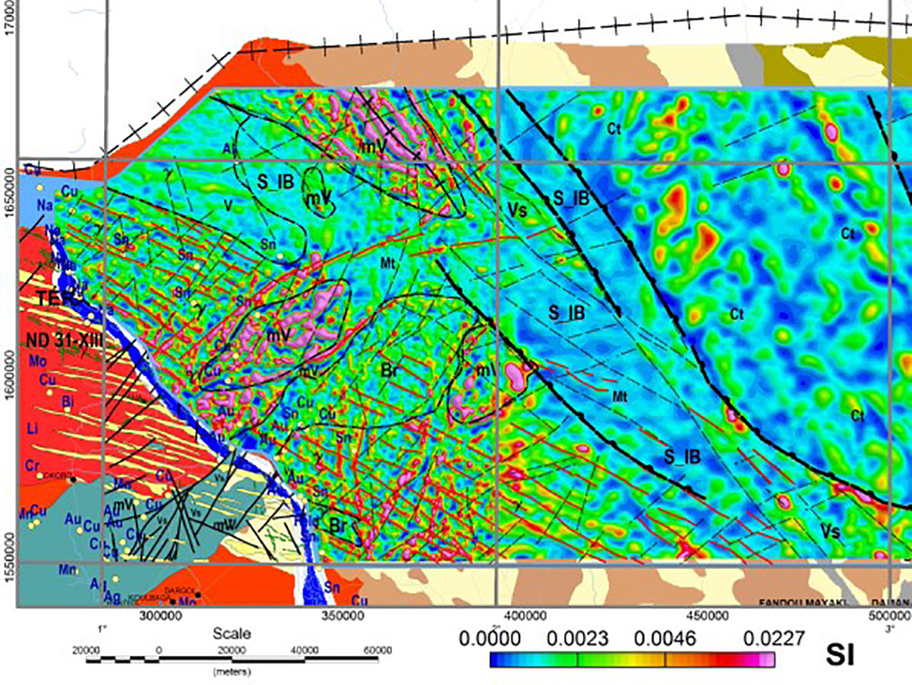
Figure 2: Magnetic interpretation results superimposed on the magnetic susceptibility depth slice (Liptako area). Lineaments in red are inferred dolerite dikes. Faults and boundaries
Regolith landform mapping
Regoliths of West Africa represent an important source of commodities including iron, bauxite and thorium (Metelka, 2011). The joint use of several data sets including Landsat TM imagery, gamma-ray spectrometer data and digital elevation models has been widely used as a standard approach for regolith mapping (Jaques, 1997). The integrated approach helped detect and delineate several regolith units within the survey area. The terrain shape, aspect and slope were calculated and used to locate highlands and plateaus. Unsupervised classification analysis helped detect thorium anomalous zones, and finally iron-rich regolith landforms were identified from the iron-oxide index and alteration maps derived from the Landsat ETM+ data (Figure 3).
Bedrock conductors detection
EM data were used to characterize the resistivity distribution of the subsurface and to help detect shallow and deep-seated alteration zones and bedrock conductors that may suggest a possible association with metallic mineralization including copper, gold, nickel and other Sulphide mineralization styles. In addition, they have been successfully used to highlight new potential areas associated with clay-bearing phosphate mineralization and lignite coal mineralized horizons near Tahoua area in the eastern portion of the sedimentary basin.
Figure 4 is a multiparameter plot including EM and 3D magnetic inversion results for a line crossing the Liptako basement. The CDI section highlights a highly conductive clay horizon on the top of the section and several steeply dipping bedrock conductors beneath the conductive clay suggesting a possible link to metallic mineralization. It also depicts a deep-seated conductive horizon attributed to the contact between the Liptako basement and overlaying sediments. Steeply dipping magnetic features highlighted in the magnetic susceptibility section are more likely associated with dolerite dikes.
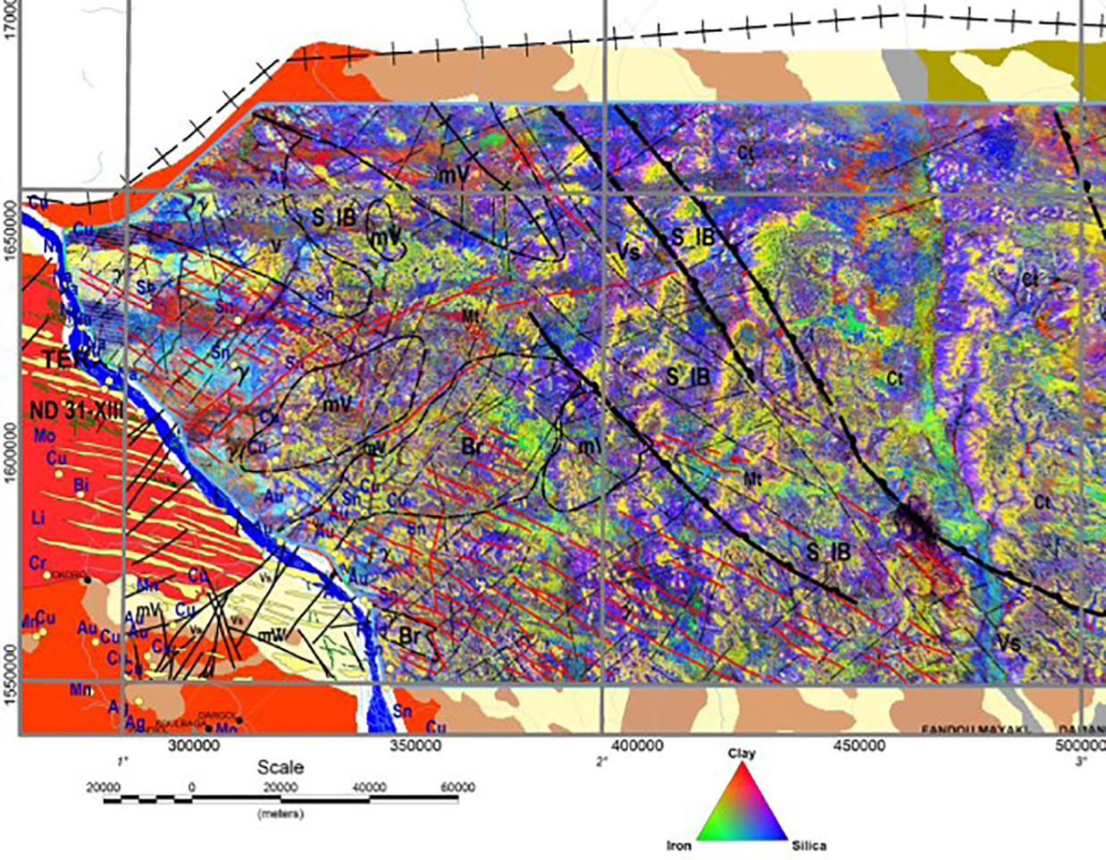
Figure 3: Alteration map derived from the Landsat ETM+ data including features of magnetic interpretation (Liptako area)
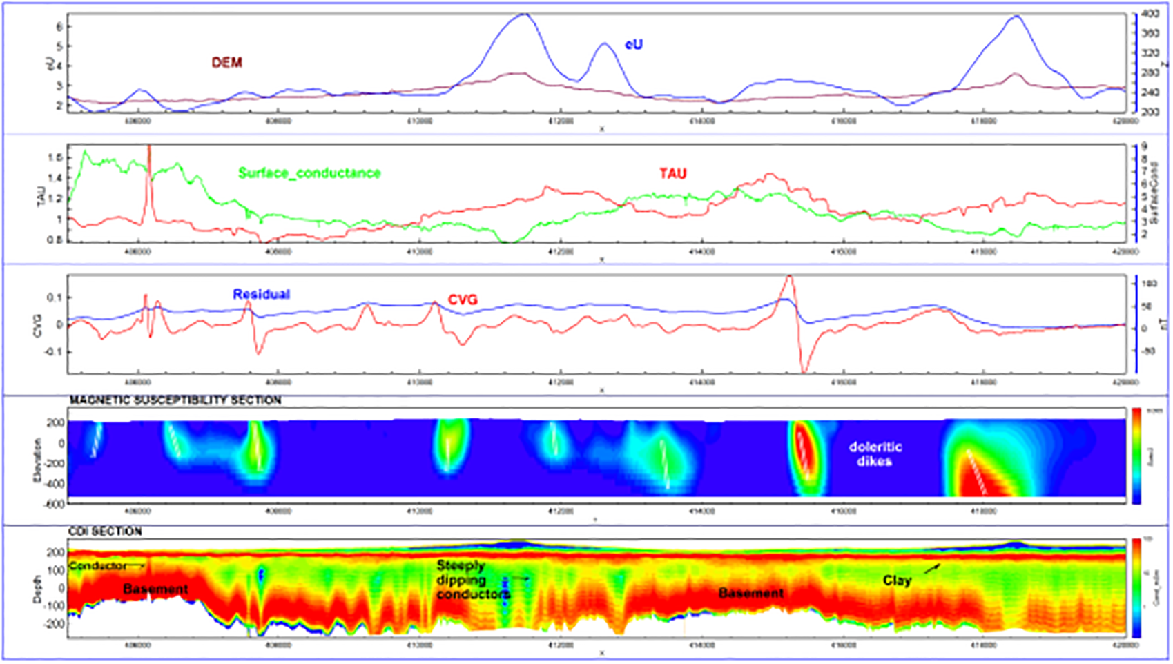
Figure 4: TEM and magnetic interpretation results. The sections are the magetic susceptibility and EMflow CDI.
Data integration Results
Geophysical data integration with other dataset types such as Landsat TM imagery, geological and geochemical data has been widely used in mining exploration for targeting and delineation of mineralized zones based on the relationship that may exist between the various mineralization types and their geophysical signatures. The approach of integrating multidisciplinary datasets is commonly used for accurate targeting and selecting favorable areas for the exploration of mineralization and alteration (Reford et al., 2004). In this study, two different algorithms have been used for mineralization targeting within the Liptako metallic province; the first is based on the Neural Network (NN) analysis, and the second on the Classification and Clustering Technique (CCT).
Neural network (NN) analysis
Neural Networks, which are composed of neurons use trained networks and interconnected non-linear transfer functions (Zang, 2000). The outcomes are represented as similarity coefficients clipped at the 90th percentile.
The input data for the NN consisted of five different datasets including the magnetic and spectrometric channels and their ratios. The training target was chosen on known mineralized zone including copper, gold and tin mineralization. Areas of high similarity coefficients represent good similarities with known mineralization and therefore, are considered as potential targets for base and precious metallic mineralization (Figure 5).
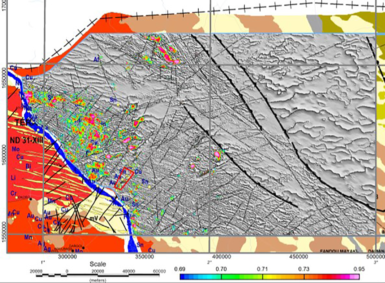
Figure 5: Neural network simulation results for copper, gold and tin mineralization targeting over the grey shaded relief magnetic image.
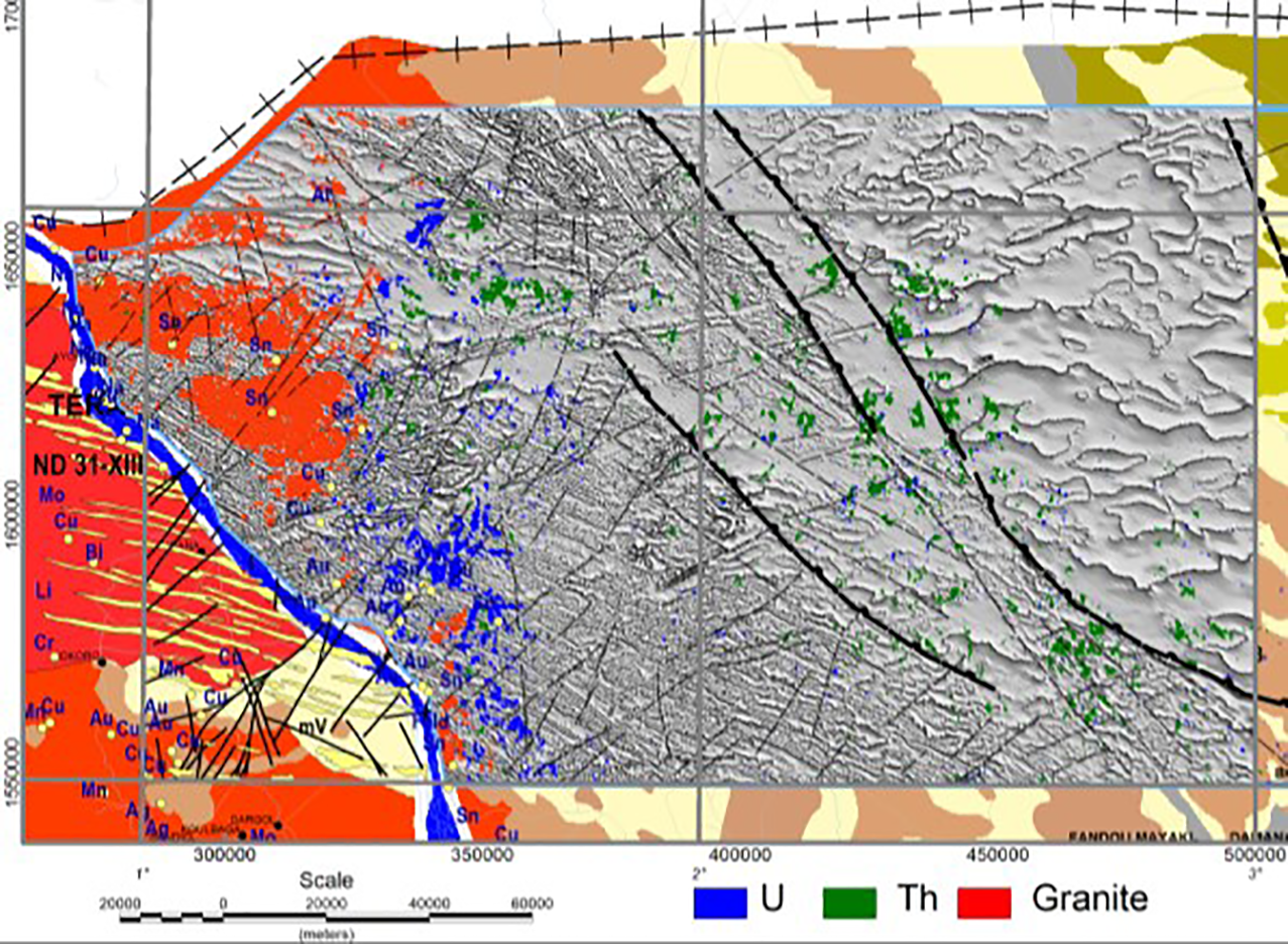
Figure 6: Supervised classification results for uranium, thorium and mineralized granite classes over the magnetic image.
Classification and clustering results
Classification is another targeting technique based on prediction concepts and may or may not require training areas (Dietterich, 1998, Jain et al., 1999). Two different approaches are used: unsupervised and supervised classifications. The supervised classification being a predictive technique requires training areas, whereas the unsupervised does not require any training area and is simply based on statistical analysis of multidisciplinary datasets. Classification techniques were used for targeting radioactive mineralization including uranium and thorium and other mineralization styles associated with intrusives such as tin and tungsten.
Results of supervised classification using the Enhanced Maximum Likelihood (EML) technique are depicted in Figure 6. As shown, many uranium clusters (blue areas) are highlighted in the western portion of the survey area within the tertiary sediments. To assess the prediction results and due to the lack of ground truthing, both posterior probability and typicality index, clipped at the 90th percentile were used to select target areas of elevated likelihood of being associated with radioactive mineralization of economic interest. In October 2013, the presence of uranium occurrence in the tertiary formations has been confirmed. As a consequence, an aggressive exploration program including detailed ground geophysical surveys has recently been initiated by the Government of Niger as a follow-up action.
Conclusions and recommendations
The analysis of the airborne magnetic, gamma-spectrometric and EM data acquired over the Iullemmeden basin of Niger has provided a new insight into the geological mapping and mineral distribution within this area, thus significantly increasing the potential mineral of the Iullemmeden basin in general and the Liptako metallogenic province in particular.
Geophysical data integration with Landsat TM imagery and geology using neural networks and classification techniques helped identify new potential targets for the exploration of various mineralization styles including base and precious metals and uranium mineralization.
Detailed ground and helicopter-borne geophysical surveys including induced polarization, gamma-ray spectrometer and Time Domain EM are highly recommended as a follow-up to the airborne geophysical survey to better define and prioritize drill-testing targets.
Acknowledgments
We are thankful to the Ministry of Mines of Niger for permission to present these results.