For a PDF of this paper click here.
Abstract
The VTEM™ and ZTEM™ helicopter-borne electromagnetic systems are examples of active source (time-domain EM) and passive natural field (tipper AFMAG) systems that were primarily designed for deep penetration mineral exploration applications. Yet, examples of successful VTEM™ and ZTEM™ applications for gold exploration also exist around the world. The VTEM™ system combines near surface high resolution resistivity imaging and deep penetration making it a low cost, “fly-to-drill” direct-detection and mapping tool. The ZTEM™ system uses worldwide sferic thunderstorm activity as its primary EM source field and, like other ground natural source EM methods, such as AMT, is capable of depths of investigation ranging from tens to thousands of meters. Coupling this with its sensitivity to weak lateral resistivity contrasts and the benefits of rapid 2D-3D inversion make it a powerful subsurface rapid reconnaissance geologic mapping tool.
Introduction
Airborne electromagnetic methods have long been highly effective detection tools for base-metal and nickel deposits, due to their high conductivity contrast with the surrounding bedrock. Helicopter time-domain EM (HTEM) systems in particular have significantly improved penetration, sensitivity and positional accuracy that easily rival ground systems. In contrast, the physical properties normally associated with gold deposits provide significant challenges for airborne EM methods, particularly for Archean lode-gold deposits whose disseminated sulphide nature and attendant quartz-potassic-carbonate alteration cause them to be virtually undetectable electromagnetically. Yet many examples of successful VTEM™ and ZTEM™ applications for gold exploration exist from around the world.
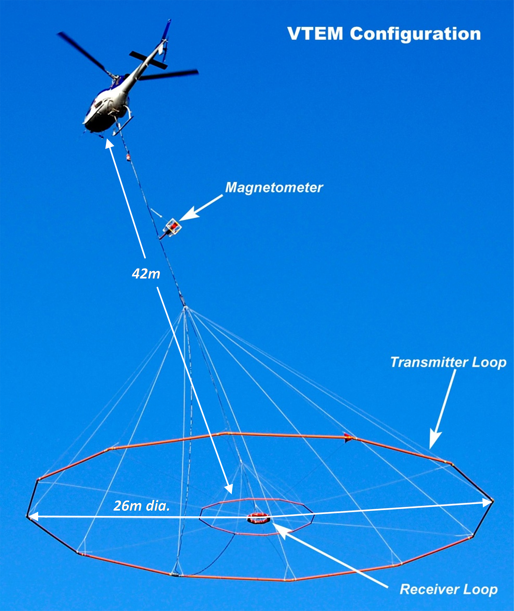
Figure 1a: VTEM™ Time-domain EM system
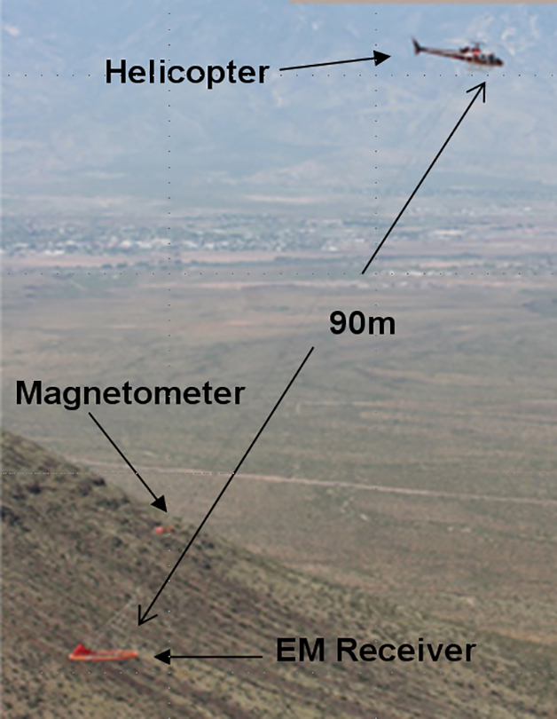
Figure 1b: ZTEM™ Natural-field AFMAG system
Geotech Ltd. was established over 25 years ago, building advanced airborne electromagnetic equipment for the exploration industry. The company’s instrumentation development has included VTEM™ (versatile time-domain electromagnetic system, Figure 1a) in 2002 that is the Geotech award winning and industry leading airborne EM technology. Winner of the 2005 Exploration Equipment award, VTEM™ is the most innovative and successful airborne EM system to be introduced in more than 30 years. More recently, Geotech introduced ZTEM™ (z-axis tipper electromagnetic) natural field airborne EM system (Figure 1b), the only commercially available AFMAG (audio frequency magneto-variational) system of its kind worldwide, airborne or ground, that is capable of penetration depths in excess of 2km in most mineral exploration environments and features a unique resistivity mapping ca-pability that rivals ground electrical surveys.
Gold Deposit Types
Gold occurs in five main geological types of deposits: 1) South African paleoplacer (47%); 2) Porphyry (20%); 3) Greenstone (13%); 4) Epithermal; and, 5) Sediment-hosted (9%), in order of abundance of world gold. South African paleoplacer deposits are unique in the world and as a result are not considered in global exploration programs. Porphyry deposits are mostly copper deposits with significant (>0.2g/t) gold associated with oxidized intrusions (Bingham, Kemess, Pebble). Also included in the porphyry group are skarns, veins and mantos (La Coipa, Cinco de Mayo), etc. Greenstone deposits are defined as those occurring in greenstone belts (Sigma, Golden Mile, Ashanti), most are Archean or Proterozoic in age and include disseminated, stockwork and vein deposits. Epithermal deposits are dominantly high sulfidation (Yanacocha); low sulfidation (Round Mountain); and exhalative (La Ronde). Sediment-hosted deposits are of two main types: Carlin-type (Goldstrike), and clastic-sediment-hosted (Muruntau, Telfer). Each of the main deposit types has its own particular geological signature in terms of: controlling structures; favourable host rocks; form of orebodies, mineralogy and textures of mineralization and associated alteration; and, associated igneous rocks (Hodgson, 2010).
VTEM™ System
The VTEM™ system has seen constant evolution and improvement since 2002, having performed over 1,500,000 km of surveys in Canada and around the world for a range of mineral deposit styles in a variety of geological settings (Witherly et al., 2004). The VTEM™ system’s very high dipole (coupled with very low system noise levels) is deemed a major differentiating factor of the system compared with others in current operation. In terms of applications, VTEM™ is seen as an effective bridge between existing airborne electromagnetics technologies; combining the high spatial resolution associated with helicopter systems but with a depth of investigation that traditionally fixed wing systems have only been able to achieve (Witherly et al., 2004). With a proven depth-detection capability for conductive bodies below 300-600m (Witherly and Irvine, 2006), the VTEM™ system is ideally suited to deep mineral exploration applications.
The standard VTEM™ system has a 26 metre diameter, vertical axis, 4 turn transmitter coil and can produce over 500,000 NIA of dipole-moment, providing its deep penetration capability. The newest high power VTEM™35 system features a larger 35m diameter loop and 1,000,000 NIA dipole-moment that have increased the depth penetration. The VTEM™ system configuration consists of 2-axis (Z-vertical & X-horizontal) induction type (dB/dt) EM receiver coils deployed in the middle of the trans-mitter coil and optically pumped caesium magnetometer suspended above it (Figure 2a). The horizontal in-loop transmitter-receiver geometry (coincident-coplanar) produces a symmetric response that is well suited for deep sounding applications. During typical surveys, the helicopter is maintained at a nominal height of 70 metres above the ground with a nominal survey speed of 80 km/hour. This allows for a nominal EM sensor terrain clearance of 35 metres and a nominal magnetic sensor clearance of 57 metres.
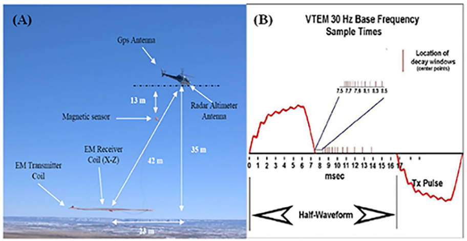
Figure 2: a) VTEM™ helicopter system, showing time-domain EM system and magnetic sensor con-figuration in flight; b) VTEM™ transmitter current waveform and off-time receiver time-gate position-ing.
The VTEM™ system has been primarily designed for mineral exploration. Its low base operating frequency – standard is 30 or 25 Hz time base operation in countries with 60 or 50 Hz power lines – and long on-time (4.6 to 7.5ms – Figure 2) pulse and B-Field data to detect and resolve high conductance targets. The VTEM™ system is ideally suited for detecting deep metallic mineralization, yet it is sufficiently versatile for other applications, including gold exploration. An example of successful application of VTEM™ for gold exploration is the Northern Empire Mine in the Beardmore-Geraldton region (Figure 3), where gold is associated with vein sulphidization and arsenopyrite replacement.
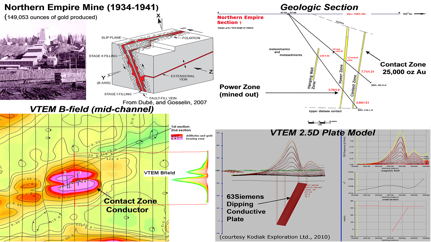
Figure 3: Northern Empire Mine gold deposit geology, VTEM™ helicopter survey results and modeling over the Contact Zone (courtesy Kodiak Exploration Inc., 2009).
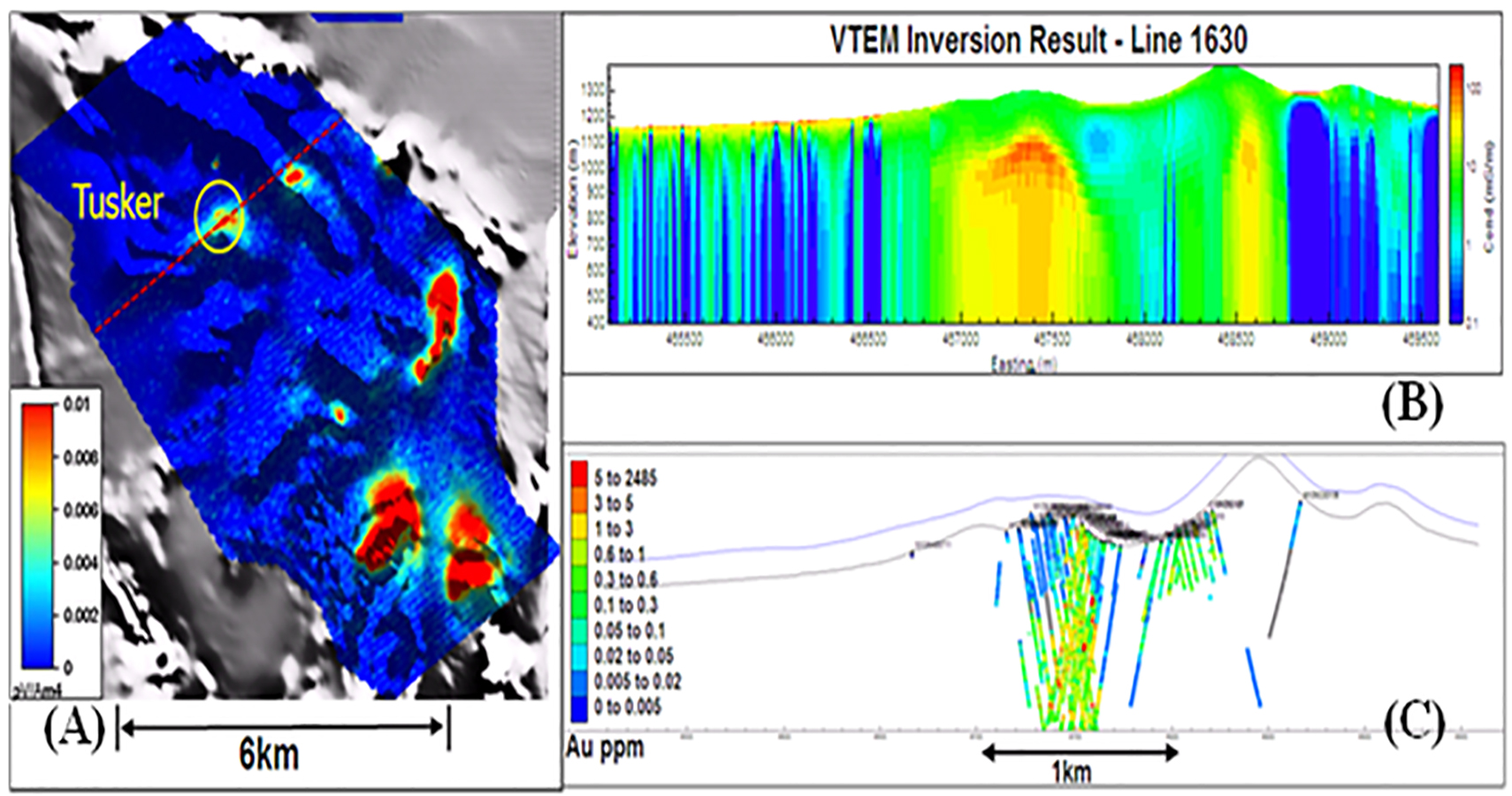
Similar examples are fewer ingold camps of the Canadian Shield system but in other areas of the world they are more common, for example at the Nkran Mine in Ghana, associated with pyritization and arsenopyritization. Elsewhere in the Ashanti Belt of Ghana, VTEM™ surveys are used as structural mapping tools for gold ore shoots hosted in graphitic shear zones along strike with the Obuasi Mine (Thomas, 2010). VTEM™ contributed to a recent major gold discovery by Barrick at the Tusker deposit in the Lake Victoria gold fields of Tanzania (Pittard and Bourne, 2009), associated with py-po-as sul-phidization in Archean sediments, as shown in Figure 4.

Figure 4: Tusker gold deposit, Tanzania: A) VTEM™ late time channel data (channel 30: 8900us) dis-played over the greyscale 1VD of RTP airborne magnetic data. The location of line 1630, on which an inverse model was run, is shown in red. B) UBC inversion result for line 1630 of VTEM™ data; C) Drill holes through the same section, with gold assays displayed in colour (after Pittard and Bourne, 2009).
ZTEM™ System
The development of the ZTEM™ (z-axis tipper electromagnetic) system (Lo and Zang, 2008; Lo et al., 2009), shown in Figure 1b, represents the first airborne application capable of deeply penetrating EM (>1-2km) that permits the mapping of geologic units, structure and alteration based on lateral resistivity contrasts. It therefore represents a unique airborne deep resistivity mapping tool that is capable of exceeding the 300-500m depth penetration limits of traditional AEM systems in mining exploration environments.
The ZTEM™ airborne AFMAG system measures the anomalous vertical secondary magnetic fields that are created by the interaction between naturally occurring, plane wave audio frequency EM fields and electrical heterogeneities in the earth. The vertical magnetic field is linearly related to the horizontal fields according to the following (Vozoff, 1972):
HZ = TXHX + TYHY
where the magnetic field vector T = (TX, TY), known as the tipper, is complex and a function of frequency, but has rotationally invariant properties, such as its magnitude and direction, that are independent of the subsurface, the measurement direction and the field polarization (Labson et al., 1985).
AFMAG uses naturally occurring audio frequency magnetic fields as the source of the primary field signal, and therefore requires no transmitter (Ward, 1959). The primary fields resemble those from VLF except that they are lower frequency (tens & hundreds of Hz versus tens of kHz) and are typically not strongly directionally polarized. These EM fields used in AFMAG are derived from world wide atmospheric thunderstorm activity, have the unique characteristic of being uniform, planar and horizontal, and also propagate vertically into the earth – to great depth, up to several km, as determined by the magnetotelluric (MT) skin depth (Vozoff, 1972), which is directly proportional to the ratio of the bedrock resistivity to the frequency. At the frequencies used for ZTEM™, the investigation depths likely range between approx. 100m to 1000m in sedimentary regions (approximately for 10-100 ohm-m average resistivity assumed), and >1000m for Precambrian Shield areas (> 1k Ω-m avg. host), as shown in Figure 5a.
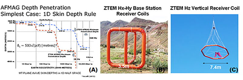
Figure 5: a) Magnetotelluric skin depth chart (left) showing the calculated ZTEM™ AFMAG minimum to maximum depth investigation versus earth resistivity; b) ZTEM™ Hx-Hy base station coils (center), c) ZTEM Hz receiver (right).
The ZTEM™ system comprises airborne tipper AFMAG as well as aeromagnetics using a caesium magnetometer (Figure 1b). The vertical (Z) component data are obtained using the Geotech ZTEM™ aircoil receiver system, suspended at approximately 85m elevation above ground level (Figure 5c). The vertical component data (Hz) are then ratioed to fixed horizontal field measurements (Hx-Hy) obtained using identical reference coils (Figure 5b). The ZTEM™ In-Phase and Quadrature tipper transfer functions are obtained using Fourier-based, digital signal processing analyses, at 6 frequencies, between 30Hz and 720Hz.
As the price of gold increases, based metals deposits, such as porphyries and massive sulphide bodies, are occasionally more valuable for their contained gold resources, for example the 5.1 billion tonne Pebble Porphyry cu-mo-au deposit in Alaska that is the 1ST largest gold and 4TH largest copper deposit in the world. Recent ZTEM™ survey results (Figure 6) define the Pebble West and deeper Pebble East deposit to below 1.5km based on favourable resistivity contrasts with the surrounding country rocks (Paré and Legault, 2010)). Carbonate replacement deposits (CRD) have represented approx 40% of Mexico’s 10 billion ounces of historical silver production. AFMAG and VTEM™ results over the Cinco de Mayo results correlate well with the Jose Manto Ag-Pb-Zn zone and the Pozo-Seco Moly-Au zones in Chihuahua, northern Mexico.
The Lalor Lake gold-copper-zinc VMS deposit in Snow Lake, MB, is a 12 million tonne gold resource (1.5g/t Au, 33 g/T Ag) in 5 lenses that is described separately from the 12.3 M tonne base-metal indicated resource in 6 other lenses within the deposit (Gilmore, 2010). ZTEM™ results over the deeply buried (~550m) Lalor Lake orebody compare favourably with the known 900mx700m deposit geology that has escaped detection in previous airborne geophysical surveys shown in Figure 7. These examples highlight the deep geologic mapping capability of the Z-axis tipper electromagnetic (ZTEM™) system.
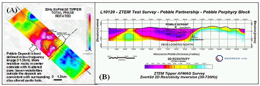
Figure 6: a) ZTEM™ total phase rotated 30Hz In-Phase results and b) 2D inversion results over Pebble cu-mo-au porphyry deposit (after Paré and Legault, 2010)
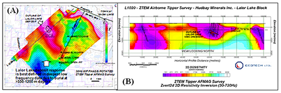
Figure 7: a) ZTEM™ phase rotated 30Hz In-Phase Z/X (in-line) results and b) 2D inversion results over Lalor Lake cu-zn-au deposit (courtesy Hudbay Minerals Ltd.).
Conclusions
In spite of significant challenges associated with the physical properties surrounding many gold deposit types, airborne EM methods have been successfully applied in gold exploration, particularly when gold occurs within more readily detectible mineral deposit types. Since Geotech’s founding 25 ago, as an advanced airborne electromagnetic equipment manufacturer, its helicopter EM system development has included the VTEM™ helicopter time-domain EM system in 2002 and the ZTEM™ natural field tipper helicopter EM system that is the only commercially available AFMAG instrument of its kind, airborne or ground. Both systems have been successfully applied in mining environments, including gold exploration targets associated with sediment and volcanic-hosted deposits in west Africa, including the Nkran and Tusker deposits and, though less commonly, in vein-hosted deposits of the Precambrian Shield, such as the Northern Empire Mine in Canada. They have also been successfully applied to gold-rich vms, mantos and porphyry exploration in North and Central America, including the Pebble and Lalor Lake deposits.
References
Gilmore, K. V., 2010, Exploration technology changes and resulting discoveries, Technical Session Abstracts, Prospectors and Developers Association of Canada, 1-4 March, Toronto, Ontario, Canada, http://www.pdac.ca/pdac/conv/2010/presentations-tech-sessions.html.
Hodgson, C.J., 2010, The types, characteristics and distribution of economically important gold deposits, Abstract of presentation at KEGS-PDAC 2010 Symposium, 28 February, Toronto, Ontario, Canada, 1p.
Labson, V. F., A. Becker, H. F. Morrison, and U. Conti, 1985, Geophysical exploration with audio-frequency natural magnetic fields: Geophysics, 50, 656–664.
Paré, P. and J.M. Legault, 2010, Ground borne IP-Resistivity, and airborne Spectrem and ZTEM survey results over Pebble copper-moly-gold porphyry, Alaska, Expanded abstract submitted to SEG International Exposition and 80th Annual Meeting, 17–22 October 2010, Denver, Colorado, USA.
Lo, B., J. M. Legault, P. Kuzmin, and M. Combrinck, 2009, ZTEM (Airborne AFMAG) tests over unconformity uranium deposits: 20TH ASEG International Geophysical Conference and Exhibition, Australian Society of Exploration Geophysicists, Extended Abstracts, 4p.
Lo, B., and M. Zang, 2008, Numerical modeling of ZTEM (airborne AFMAG) responses to guide ex-ploration strategies, SEG Expanded Abstracts, 27, 1098–1101.
Pittard, K., and B. Bourne, 2009, The Geophysical Response of the Tusker Gold Deposit, Lake Victoria Gold Fields, Tanzania, 20TH ASEG International Geophysical Conference and Exhibition, Australian Society of Exploration Geophysicists, Extended Abstracts.
Thomas, S, 2010, Case Study of Four VTEM Surveys for Gold Exploration in Ghana, Expanded abstract presented at KEGS-PDAC 2010 Symposium, 28 February, Toronto, Ontario, Canada, 6p.
Vozoff, K., 1972, The magnetotelluric method in the exploration of sedimentary basins: Geophysics, 37, 98–141.
Ward, S. H., 1959, AFMAG: Airborne and ground: Geophysics, 24, 761–787.
Witherly, K., and R. Irvine, 2006, The VTEM airborne electromagnetic system – benchmarking continuous improvement via repeat surveys over time, SEG Expanded Abstracts, 25, 1273-1277.
Witherly, K., R. Irvine, and E. B. Morrison, 2004, The Geotech VTEM time domain helicopter EM system, SEG Expanded Abstracts, 23, 1217–1221.