For a PDF of this paper click here
Introduction
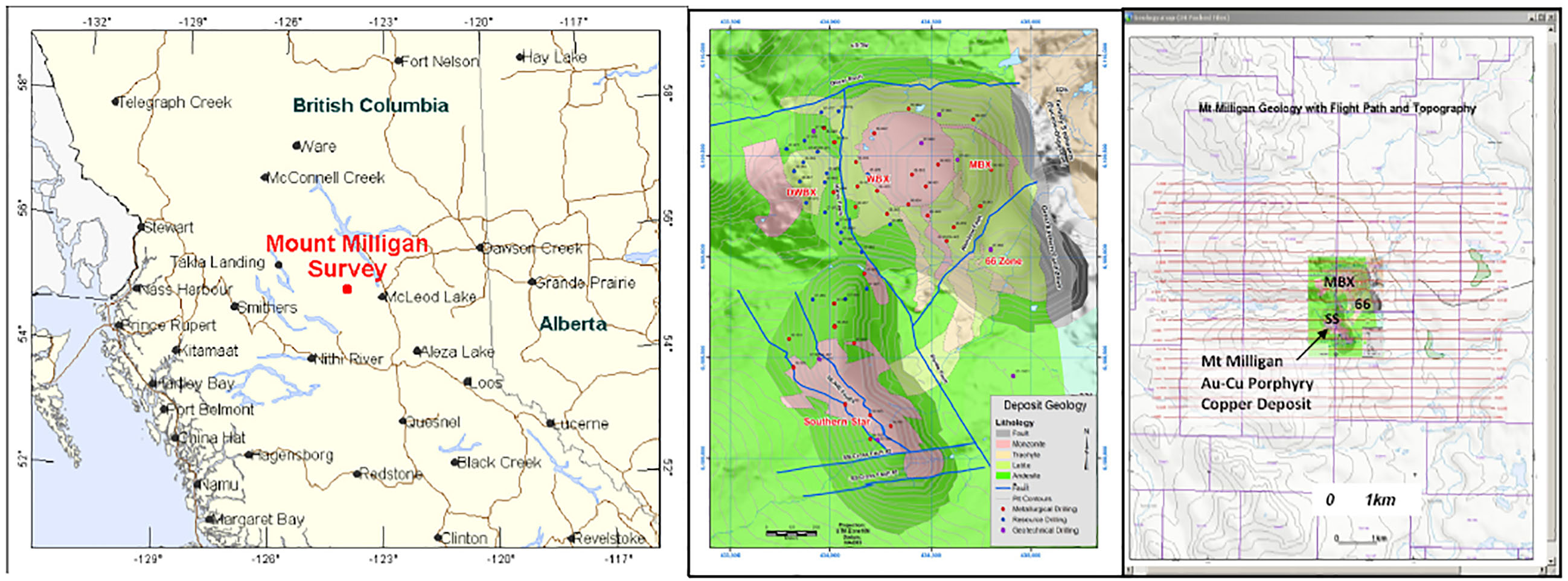
ZTEM™ (Z-Axis Tipper Electromagnetic) surveys were conducted, on behalf of Geoscience BC (Project 2008-32), over the Mt. Milligan Property, belonging to Terrane Metals Corp. (Vancouver, BC) and situated in the Mackenzie region of central British-Columbia (Figure 1a), between October 15TH to 22ND, 2008. The ZTEM™ survey comprised airborne Tipper AFMAG (audio frequency electromagnetics) measurements, as well as aeromagnetics using a caesium magnetometer. The survey consisted of twenty five (25) approx. 8.0 km long, EW oriented flight lines, totaling 200 line-km, that were obtained at nominal 250m line spacings over an approximately 6 x 8 km area (Figure 1c). The area was chosen because it hosts the Mt Milligan copper-gold porphyry deposit, containing a Measured and Indicated Mineral Resource of 590.8 Mt at 0.193% Cu and 0.352 g/t Au, totaling 2.52 billion lb copper and 6.70 million oz gold (Terrane Metals Corp., NI 43-101, 2007), that is not yet in production, and also because area’s geology is well known and available in the public domain – making it an ideal case-study example.

Figure 1: a) Mt. Milligan property location (left), b) general geology (center), c) ZTEM flight lines (right
Deposit Geology
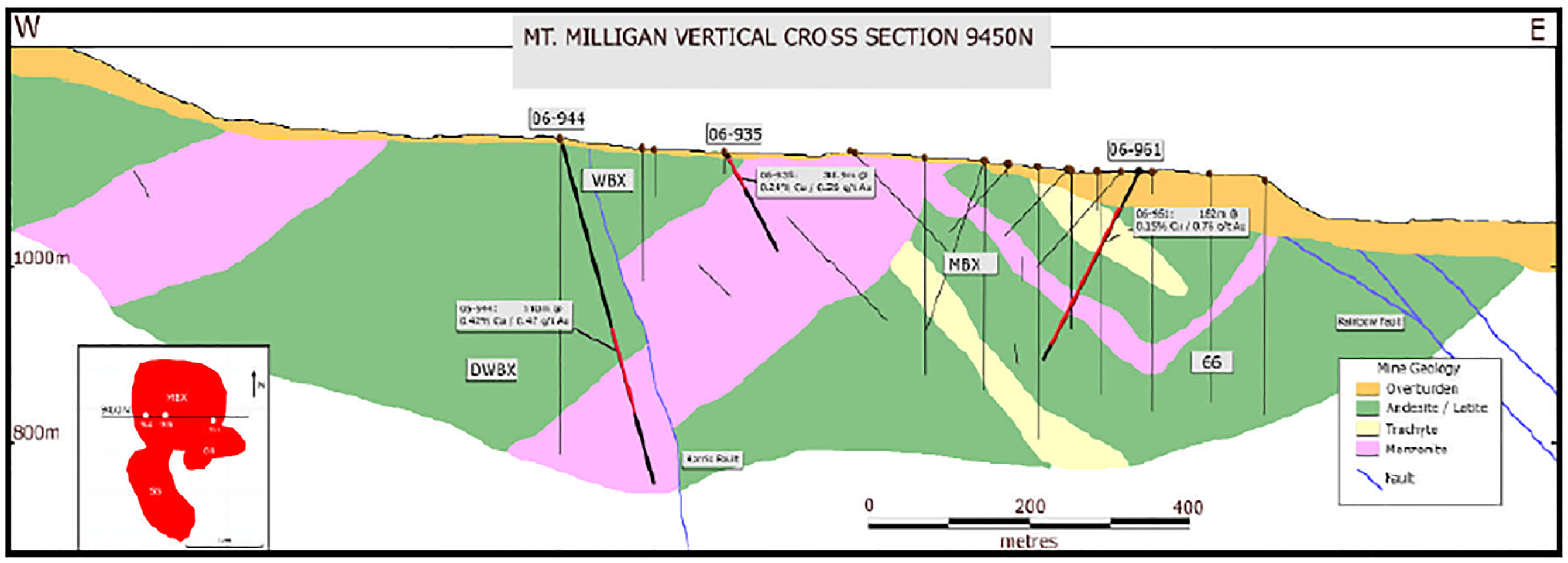
The Mt. Milligan project is within the Quesnel Terrane, a Late Triassic to Early Jurassic magmatic arc complex (Terrane Minerals Corp., 2008). The Quesnellia rocks consist of Triassic to Lower Jurassic volcanic and minor sedimentary rocks of Takla Group. The Takla Group in the Mt. Milligan area is mainly comprised of an upper, predominantly volcaniclastic Witch Lake Succession with hosts the Mt. Milligan deposits. The Witch Lake rocks are characterized by volcaniclastic and basaltic andesites that are intruded by coeval Takla Group and younger intrusions. Coeval intrusions comprise most of the Mt. Milligan intrusive complex, which consists dominantly of monzonitic rocks – including the MBX, Southern Star, Goldmark and North Slope stocks, all which host mineralization at Mt. Milligan (Figure 1c). Mt. Milligan is a tabular, near-surface, alkalic copper-gold porphyry deposit that measures some 2500 metres (m) north-south, 1500 m east-west and is 400 m thick. It consists of two principal zones, the Main Zone and Southern Star (SS) Zone. The Main Zone includes four contiguous sub-zones: MBX, WBX, DWBX and 66, all of which are spatially associated with the MBX monzonite stock and Rainbow Dyke (Figures 1b, 2). Mineralization in both zones consists of pyrite, chalcopyrite and magnetite with bornite local¬ized along intrusive-volcanic contacts (Terrane Minerals Corp., NI 43-101, 2007).

Figure 2: Cross-section across MBX Stock at Mt. Milligan (after Terrane Metals Corp., NI 43-101, 2007).
Copper-gold mineralization is primarily associated with potassic alteration with both copper grade and alteration intensity decreasing outwards from the monzonite stocks. Pyrite content increases dramatically outward from the stocks where it occurs in association with propylitic alteration, which forms a halo around the potassic-altered rocks. In terms of alteration, Mt. Milligan features a poorly developed supergene blanket over the deposit with limited supergene enrichment. Potassic alteration is widespread and occurs principally as massive K-feldspar and biotite replacement of fine-grained matrix in porphyritic tuffs and flows. A phase of propylitic alteration consisting of epidote-calcite+/-pyrite-albite-chlorite in part overprints the potassic alteration (Terrane Minerals Corp., NI 43-101, 2007).
ZTEM Tipper AFMAG Results
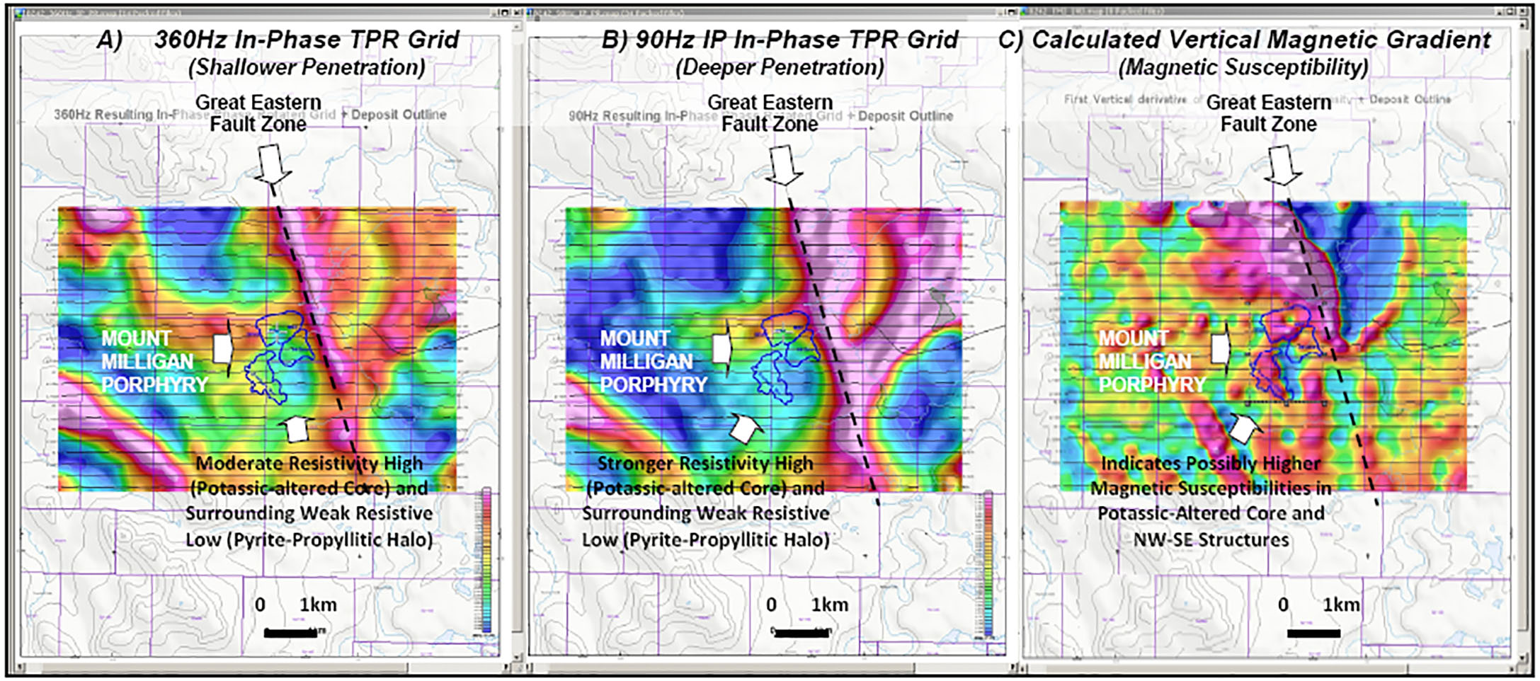
To better highlight the ZTEM results in plan, the Tzx and Tzy tipper cross-over data are phase-rotated and combined into a Total Phase Rotated (TPR) grid image. The high and mid-frequency In-Phase TPR grid images shown in Figure 3 point to noticeable differences in the frequency-dependence of the responses, that imply resolved differences in the vertical depth of these defined structures: For exam¬ple, the main NNW-SSE Great Eastern Fault zone contact response, occurring east of Mt Milligan, that progressively strengthens from high to low frequency (Fig. 3a & 3b). Highlighted in the TPR images is the subtle oval-shaped, and rimmed high resistivity anomaly that also strengthens with depth and coincides with the Mt. Milligan porphyry, reflecting the potassic altered core and surrounding weak pro¬pyllitic alteration halo. The magnetic CVG results (Fig. 3c) appear to reflect higher ferromagnetic minerals within the K-altered core.

ZTEM Tipper AFMAG field results shown in plan as grid contours the Total Phase Rotated (TPR) In-Phase ZTEM tipper data and Mt. Milligan deposit outlines: a) 360Hz high frequency IP TPR (left) and b) 90Hz mid-frequency IP TPR (centre) showing resistivity contrasts surrounding Mt. Milligan and Great Eastern Fault zones, b) Calculated vertical gradient (CVG) of Magnetic TMI image showing distributions of ferromagnetic minerals (right).
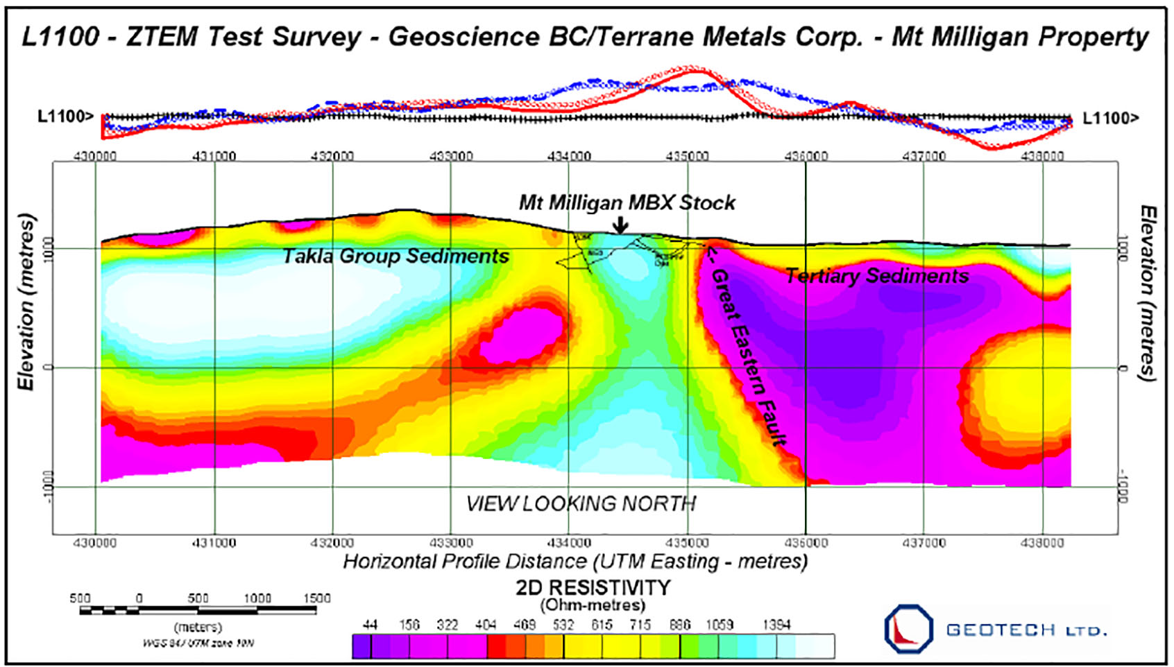
The In-line (Tzx) data for a single line profile, taken directly over the center of the Mt Milligan Main Zone Porphyry (MBX), were used to create the 2D inversion image presented in Figure 4. A uniform host of 1000 ohm-metres was assumed for the starting model. The re¬sistive rocks to the west correspond undifferentiated Takla Group sediments, that appear to extend to >1km depths based on the ZTEM inversion results. The conductive rocks imaged furthest east correspond to the known Tertiary Sediments that lie east of the older Quesnel-Takla rocks that host the Mt Milligan porphyry, whose boundary is marked by the Great Eastern Fault Zone, which appears to be east-dipping. More importantly, the central resistivity high coincides with the Mt Milligan MBX zone and related potassic altered zone. Below and west of the central MBX stock, a moderate resistivity low feature appears to dip westward and extends to below sev¬eral km depths – suggesting a structural zone that resembles the geologic cross-section shown in Figure 2.
