For a PDF of the paper click here
Introduction
As part of a larger geophysical survey program, Geotech Ltd. carried out a helicopter-borne ZTEM (Z-axis Tipper Electromagnetic) survey test over the Morrison Copper/Gold Property, belonging to Pacific Booker Minerals Inc. (Vancouver, BC), in May, 2010. The Morrison Property and adjoining Hearne Hill Property (Figure 1b), are situated in the Babine Lake Region of central BC, approximately 65 km northeast of the town of Smithers and 35 km north of Granisle village, and lie within 30km of the former Granisle and Bell porphyry copper/gold mines (Figure 1a). Principal geophysical sensors included the ZTEM AFMAG (audio frequency magnetics) system and caesium magnetometer. A total of 163 km were flown along 15 x 10.9km long profiles at a nominal line-spacing of 250m over a 38 km2 area (Figure 1c). The objective of the ZTEM survey was to determine its ability to detect and map the Morrison and Hearne Hill porphyry copper deposits, based on resistivity contrasts derived from airborne tipper measurements.
Deposit Geology
The Morrison deposit is classified as a calc-alkaline copper-gold porphyry, whose geologic settings and general style of hydrothermal alteration and mineralization are similar to other porphyry deposits in the northern Babine Lake area. Babine Lake is a well-known and historically significant porphyry copper district that hosts dozens of deposits and occurrences, all spatially related to the Eocene Babine Intrusions, that include most notably the past-producing Granisle (152.7 Mt @ 0.47% Cu, 0.20 g/t Au) and Bell (77.2 Mt @ 0.47% Cu, 0.26 g/t Au) mines. The Hearne Hill deposit, which lies 2.0km southeast of Morrison, is a comparatively small but high grade copper-gold resource in two breccia pipes defined within a larger porphyry system and hosting an indicated resource (non 43-101 compliant) of 2.9 Mt @ 0.72% Cu and 0.23 g/t Au. The Morrison deposit contains a measured and indicated resource of 208.2 Mt averaging 0.39% Cu, 0.19 g/t Au and 0.005% Mo. It is currently at the advanced mine feasibility stage (Ref. J. Robertoson, NI 43-101 report, Mar-2009).
The Morrison property is situated on the northern edge of the Skeena Arch in a region underlain by volcanic, clastic, and epiclastic rocks ranging in age from the Lower Jurassic to Lower Cretaceous. The property geology is dominated by the 1.5-2km wide Morrison Graben that is NW-SE trending (Figure 1b) and hosts Mid Jurassic Ashman Formation siltstone, sandstone and greywacke sediments that are locally intruded by Eocene Babine Intrusions of biotite feldspar porphyry (BFP), quartz diorite and granodiorite. These rocks are down-faulted relative to older Lower Jurassic Hazleton volcanics and sediments to the east and west of the graben (Figure 1b). The copper-gold porphyry mineralization at Morrison is developed in a BFP plug and related dykes. The hydrothermal alteration at Morrison is concentrically zoned with a central potassic altered core surrounded by chlorite-carbonate zone. No well developed phyllic alteration has been identified at Morrison. Sulphides show strong relationships with underlying BFP plug, with the abundance of pyrite decreasing towards the center of the Morrison deposit along with 0.2% Cu associated with chalcopyrite. The deposit has been defined to below 400m depths (Figure 2) but remains open at depth, with the deepest mineralized drillhole depth of 700m below surface. A pyrite halo developed in the chlorite-carbonate altered wall rocks surrounds the copper zone and contains 5-15% pyrite down to 1-2% at the edges. The Morrison Fault is believed to dextrally disrupt the Morrison/Hearne Hill copper-gold porphyry system into two displaced bodies, 2.0 km apart, with the Morrison deposit representing the downward extension of the higher level Hearne Hill deposit. The Morrison deposit is also displaced by the East and West dextral on echelon faults (Ref. J. Robertson, NI 43-101 report, Mar-2009).
ZTEM System
The ZTEM survey instrumentation consists of a single vertical-dipole receiver coil (7.4m dia.) that is towed roughly 80m below the helicopter, at a 100m nominal flight height, and is flown over the survey area in a grid pattern, similar to other regional airborne surveys. Two orthogonal air-core horizontal axis coils (3.5m dia.) are placed close to the survey site to measure the horizontal EM reference fields. Data from the three coils are used to obtain the Z/X (In-line) and Z/Y (cross-line) AFMAG tippers, whose transfer functions (In-Phase & Quadrature) are derived at five to six frequencies in the 30 to 720 Hz band. ZTEM tipper AFMAG is recognized for its unique ability to map resistivity contrasts associated with lithology, structure and particularly the alteration zones that are typically associated with porphyry copper and other similar deposits to great depths, exceeding 1-2km.
ZTEM Tipper AFMAG Results
Figure 2 presents the ZTEM survey results in plan, comparing the Total Divergence (DT) images (that convert the tipper cross-overs into peaks) of the In-Phase tipper data at 90Hz (left) and the Total Magnetic Intensity (TMI) responses (right), with the outline of the Morrison and Hearne Hill deposits overlain, as well as selected tipper profile data. In the DT image, warm colours represent conductive structures and contacts; cool colours represent more resistive units. The Morrison deposit is well defined in the 90Hz mid frequency DT data as a higher resistivity anomaly that is consistent with its potassic altered core. The DT resistivity high is in turn surrounded by a U-shaped lower resistivity border, which is normally consistent with the more conductive pyrite-rich alteration halo, but could otherwise also be due to fault-fracture structure associated with the Morrison Graben. The TMI image shows that the Morrison deposit is weakly magnetic, which is also consistent with the expected alteration in the core; the surrounding low magnetism matches the DT conductive zone and suggests magnetite-depletion associated with the pyrite halo. The Hearne Hill deposit occurs above a larger magnetic high, likely associated with an intrusive, and lies with a broad band of more conductive NE-trending rocks – possibly due to the breccia zones or a discordant fault/clay-alteration zone. Figure 3 presents the 2D cross-sectional resistivity data results obtained from the 2D inversion of the In-Line (Tx) ZTEM tipper data from the L1110 profile directly over Morrison deposit (Fig 2) using Geotech’s proprietary Zvert2d code. The 2D inversion image defines a subcropping resistive body, consistent with the known potassic altered core, which gradually pinches below 500-750m depth that seems consistent with the known deposit geology. The Morrison high is flanked by 2 steeply conductive features that either possibly represent the pyritic alteration halos or more likely the faulted edges of the Morrison Graben.
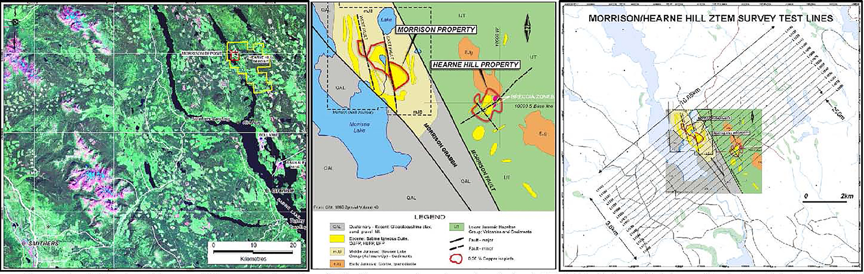
Figure 1: a) Morrison/Hearne Hill property location (left), b) General Geology (center), c) ZTEM flight lines (right; modified after Robertson, 2009).
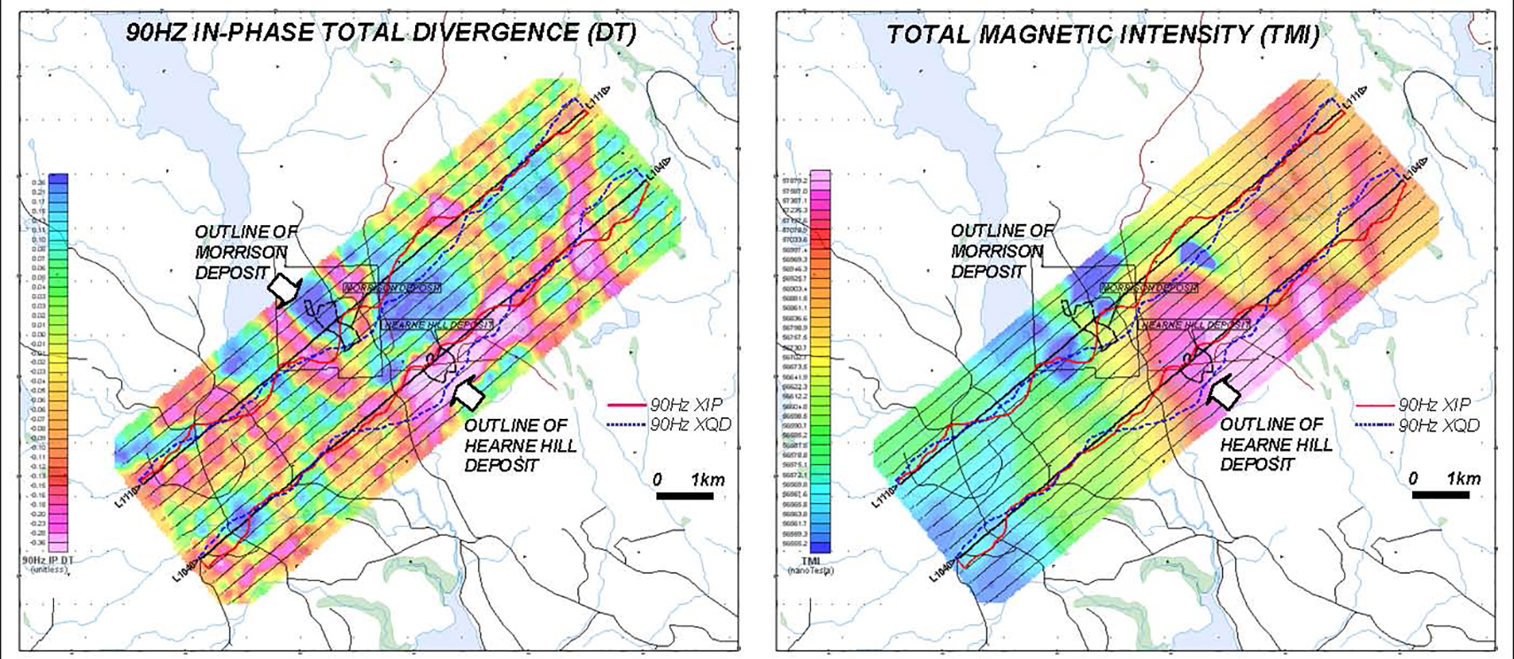
Figure 2: ZTEM Tipper AFMAG field results shown in plan as grid contours of In-Phase Total Divergence (DT): a) 90Hz mid frequency IP DT showing resistivity contrasts (left) and b) Magnetics TMI image is showing distributions of ferromagnetic minerals (right) and Morrison + Hearne Hill deposit outlines.
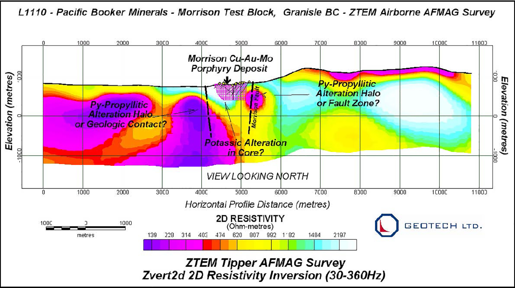
Figure 3: 2D Resistivity cross-section for L1110 over centre of Morrison Lake deposit from Zvert2d inversion of ZTEM In-line (Z/X) tipper data.